


Voting District 0998400000052, Macomb County, Michigan
About
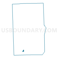
Outline

Summary
| Unique Area Identifier | 597851 |
| Name | Voting District 0998400000052 |
| County | Macomb County |
| State | Michigan |
| Area (square miles) | 0.53 |
| Land Area (square miles) | 0.53 |
| Water Area (square miles) | 0.00 |
| % of Land Area | 99.83 |
| % of Water Area | 0.17 |
| Latitude of the Internal Point | 42.48273210 |
| Longtitude of the Internal Point | -82.97355430 |
Maps

Graphs
Select a template below for downloading or customizing gragh for Voting District 0998400000052, Macomb County, Michigan


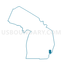
Neighbors
Neighoring Voting District (by Name) Neighboring Voting District on the Map
- Voting District 0992429000005, Macomb County, MI
- Voting District 0996980000001, Macomb County, MI
- Voting District 0996980000002, Macomb County, MI
- Voting District 0996980000008, Macomb County, MI
- Voting District 0996980000009, Macomb County, MI
- Voting District 0998400000036, Macomb County, MI
- Voting District 0998400000037, Macomb County, MI
- Voting District 0998400000050, Macomb County, MI
- Voting District 0998400000053, Macomb County, MI
Top 10 Neighboring County Subdivision (by Population) Neighboring County Subdivision on the Map
- Warren city, Macomb County, MI (134,056)
- Roseville city, Macomb County, MI (47,299)
- Eastpointe city, Macomb County, MI (32,442)
Top 10 Neighboring Place (by Population) Neighboring Place on the Map
Top 10 Neighboring Unified School District (by Population) Neighboring Unified School District on the Map
- Roseville Community Schools, MI (43,312)
- East Detroit Public Schools, MI (38,049)
- Warren Woods Public Schools, MI (21,160)
Top 10 Neighboring State Legislative District Lower Chamber (by Population) Neighboring State Legislative District Lower Chamber on the Map
Top 10 Neighboring State Legislative District Upper Chamber (by Population) Neighboring State Legislative District Upper Chamber on the Map
Top 10 Neighboring 111th Congressional District (by Population) Neighboring 111th Congressional District on the Map
Top 10 Neighboring Census Tract (by Population) Neighboring Census Tract on the Map
- Census Tract 2629, Macomb County, MI (4,122)
- Census Tract 2582, Macomb County, MI (2,865)
- Census Tract 2561, Macomb County, MI (2,662)
- Census Tract 2628, Macomb County, MI (2,378)
- Census Tract 2560, Macomb County, MI (2,080)
- Census Tract 2568, Macomb County, MI (1,750)
- Census Tract 2676, Macomb County, MI (1,443)