


Voting Districts not defined, Luce County, Michigan
About
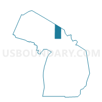
Outline

Summary
| Unique Area Identifier | 597725 |
| Name | Voting Districts not defined |
| County | Luce County |
| State | Michigan |
| Area (square miles) | 815.63 |
| Land Area (square miles) | 0.01 |
| Water Area (square miles) | 815.62 |
| % of Land Area | 0.00 |
| % of Water Area | 100.00 |
| Latitude of the Internal Point | 46.71644330 |
| Longtitude of the Internal Point | -85.36448900 |
Maps


Graphs
Select a template below for downloading or customizing gragh for Voting Districts not defined, Luce County, Michigan


Neighbors
Neighoring Voting District (by Name) Neighboring Voting District on the Map
- Voting District 0955044000001, Luce County, MI
- ZZZZZZ, Alger County, MI
- Voting Districts not defined, Chippewa County, MI
Top 10 Neighboring County Subdivision (by Population) Neighboring County Subdivision on the Map
- McMillan township, Luce County, MI (2,692)
- County subdivisions not defined, Luce County, MI (0)
- County subdivisions not defined, Chippewa County, MI (0)
- County subdivisions not defined, Alger County, MI (0)
Top 10 Neighboring Unified School District (by Population) Neighboring Unified School District on the Map
- Tahquamenon Area Schools, MI (7,851)
- Brimley Area Schools, MI (3,276)
- Burt Township School District, MI (522)
Top 10 Neighboring State Legislative District Lower Chamber (by Population) Neighboring State Legislative District Lower Chamber on the Map
Top 10 Neighboring State Legislative District Upper Chamber (by Population) Neighboring State Legislative District Upper Chamber on the Map
Top 10 Neighboring 111th Congressional District (by Population) Neighboring 111th Congressional District on the Map
Top 10 Neighboring Census Tract (by Population) Neighboring Census Tract on the Map
- Census Tract 9602, Luce County, MI (2,147)
- Census Tract 9900, Chippewa County, MI (0)
- Census Tract 9900, Alger County, MI (0)
- Census Tract 9900, Luce County, MI (0)