


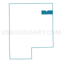
Voting District 0492942000003, Genesee County, Michigan
About
Outline

Summary
| Unique Area Identifier | 596474 |
| Name | Voting District 0492942000003 |
| County | Genesee County |
| State | Michigan |
| Area (square miles) | 11.64 |
| Land Area (square miles) | 11.61 |
| Water Area (square miles) | 0.03 |
| % of Land Area | 99.77 |
| % of Water Area | 0.23 |
| Latitude of the Internal Point | 43.14856710 |
| Longtitude of the Internal Point | -83.51345030 |
Maps

Graphs
Select a template below for downloading or customizing gragh for Voting District 0492942000003, Genesee County, Michigan


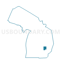
Neighbors
Neighoring Voting District (by Name) Neighboring Voting District on the Map
- Voting District 0492942000001, Genesee County, MI
- Voting District 0492942000002, Genesee County, MI
- Voting District 0493180000014, Genesee County, MI
- Voting District 0496818000001, Genesee County, MI
- Voting District 0496818000004, Genesee County, MI
- Voting District 0497946000003, Genesee County, MI
- Voting District 0875142000001, Lapeer County, MI
- Voting District 0876106000002, Lapeer County, MI
Top 10 Neighboring County Subdivision (by Population) Neighboring County Subdivision on the Map
- Genesee charter township, Genesee County, MI (21,581)
- Richfield township, Genesee County, MI (8,730)
- Thetford township, Genesee County, MI (7,049)
- Oregon township, Lapeer County, MI (5,786)
- Forest township, Genesee County, MI (4,702)
- Marathon township, Lapeer County, MI (4,568)
Top 10 Neighboring Place (by Population) Neighboring Place on the Map
Top 10 Neighboring Unified School District (by Population) Neighboring Unified School District on the Map
- Clio Area School District, MI (20,392)
- Mount Morris Consolidated School District, MI (14,430)
- Lakeville Community Schools, MI (12,000)
- Genesee School District, MI (3,090)
Top 10 Neighboring State Legislative District Lower Chamber (by Population) Neighboring State Legislative District Lower Chamber on the Map
- State House District 82, MI (88,319)
- State House District 50, MI (85,058)
- State House District 48, MI (83,139)
Top 10 Neighboring State Legislative District Upper Chamber (by Population) Neighboring State Legislative District Upper Chamber on the Map
- State Senate District 26, MI (275,787)
- State Senate District 27, MI (256,301)
- State Senate District 25, MI (251,359)
Top 10 Neighboring 111th Congressional District (by Population) Neighboring 111th Congressional District on the Map
Top 10 Neighboring Census Tract (by Population) Neighboring Census Tract on the Map
- Census Tract 3421, Lapeer County, MI (3,539)
- Census Tract 124.02, Genesee County, MI (2,797)
- Census Tract 3315, Lapeer County, MI (2,747)
- Census Tract 119.01, Genesee County, MI (2,523)
- Census Tract 121, Genesee County, MI (2,506)
- Census Tract 125.01, Genesee County, MI (2,033)
- Census Tract 124.01, Genesee County, MI (1,905)