


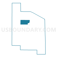
Voting District 0173040000002, Bay County, Michigan
About
Outline

Summary
| Unique Area Identifier | 595945 |
| Name | Voting District 0173040000002 |
| County | Bay County |
| State | Michigan |
| Area (square miles) | 17.00 |
| Land Area (square miles) | 16.91 |
| Water Area (square miles) | 0.09 |
| % of Land Area | 99.50 |
| % of Water Area | 0.50 |
| Latitude of the Internal Point | 43.80717590 |
| Longtitude of the Internal Point | -83.99186160 |
Maps


Graphs
Select a template below for downloading or customizing gragh for Voting District 0173040000002, Bay County, Michigan


Neighbors
Neighoring Voting District (by Name) Neighboring Voting District on the Map
- Voting District 0173040000001, Bay County, MI
- Voting District 0173154000001, Bay County, MI
- Voting District 0175592000001, Bay County, MI
- Voting District 0176418000001, Bay County, MI
- Voting Districts not defined, Bay County, MI
Top 10 Neighboring County Subdivision (by Population) Neighboring County Subdivision on the Map
- Fraser township, Bay County, MI (3,192)
- Pinconning township, Bay County, MI (2,431)
- Garfield township, Bay County, MI (1,743)
- Mount Forest township, Bay County, MI (1,392)
Top 10 Neighboring Unified School District (by Population) Neighboring Unified School District on the Map
Top 10 Neighboring State Legislative District Lower Chamber (by Population) Neighboring State Legislative District Lower Chamber on the Map
Top 10 Neighboring State Legislative District Upper Chamber (by Population) Neighboring State Legislative District Upper Chamber on the Map
Top 10 Neighboring 111th Congressional District (by Population) Neighboring 111th Congressional District on the Map
Top 10 Neighboring Census Tract (by Population) Neighboring Census Tract on the Map
- Census Tract 2862, Bay County, MI (4,935)
- Census Tract 2863, Bay County, MI (3,738)
- Census Tract 2864, Bay County, MI (2,602)