


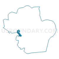
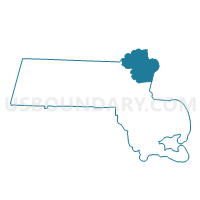
Middleton Precinct 1, Essex County, Massachusetts
About
Outline

Summary
| Unique Area Identifier | 594002 |
| Name | Middleton Precinct 1 |
| County | Essex County |
| State | Massachusetts |
| Area (square miles) | 7.39 |
| Land Area (square miles) | 6.74 |
| Water Area (square miles) | 0.65 |
| % of Land Area | 91.24 |
| % of Water Area | 8.76 |
| Latitude of the Internal Point | 42.60071850 |
| Longtitude of the Internal Point | -71.03082260 |
Maps

Graphs
Select a template below for downloading or customizing gragh for Middleton Precinct 1, Essex County, Massachusetts


Neighbors
Neighoring Voting District (by Name) Neighboring Voting District on the Map
- Danvers Precinct 8, Essex County, MA
- Lynnfield Precinct 4, Essex County, MA
- Middleton Precinct 2, Essex County, MA
- North Andover Precinct 7, Essex County, MA
- North Andover Precinct 8, Essex County, MA
- North Reading Precinct 1, Middlesex County, MA
- Peabody Ward 6 Precinct 2, Essex County, MA
- Peabody Ward 6 Precinct 3, Essex County, MA
Top 10 Neighboring County Subdivision (by Population) Neighboring County Subdivision on the Map
- Peabody city, Essex County, MA (51,251)
- North Andover town, Essex County, MA (28,352)
- Danvers town, Essex County, MA (26,493)
- North Reading town, Middlesex County, MA (14,892)
- Lynnfield town, Essex County, MA (11,596)
- Middleton town, Essex County, MA (8,987)
Top 10 Neighboring Place (by Population) Neighboring Place on the Map
Top 10 Neighboring Elementary School District (by Population) Neighboring Elementary School District on the Map
Top 10 Neighboring Secondary School District (by Population) Neighboring Secondary School District on the Map
Top 10 Neighboring Unified School District (by Population) Neighboring Unified School District on the Map
- Peabody School District, MA (51,251)
- North Andover School District, MA (28,352)
- Danvers School District, MA (26,493)
- North Reading School District, MA (14,892)
- Lynnfield School District, MA (11,596)
Top 10 Neighboring State Legislative District Lower Chamber (by Population) Neighboring State Legislative District Lower Chamber on the Map
- Twentieth Middlesex District, MA (43,378)
- Eighteenth Essex District, MA (41,945)
- Fourth Essex District, MA (40,890)
- Thirteenth Essex District, MA (39,969)
Top 10 Neighboring State Legislative District Upper Chamber (by Population) Neighboring State Legislative District Upper Chamber on the Map
- First Essex District, MA (170,805)
- First Essex & Middlesex District, MA (169,764)
- Second Essex District, MA (164,671)
- Middlesex & Essex District, MA (161,537)
Top 10 Neighboring 111th Congressional District (by Population) Neighboring 111th Congressional District on the Map
Top 10 Neighboring Census Tract (by Population) Neighboring Census Tract on the Map
- Census Tract 2121, Essex County, MA (8,987)
- Census Tract 3301, Middlesex County, MA (8,231)
- Census Tract 2101, Essex County, MA (6,948)
- Census Tract 2092, Essex County, MA (5,508)
- Census Tract 2532.04, Essex County, MA (5,329)
- Census Tract 2532.05, Essex County, MA (4,345)
- Census Tract 2114.01, Essex County, MA (3,560)
Top 10 Neighboring 5-Digit ZIP Code Tabulation Area (by Population) Neighboring 5-Digit ZIP Code Tabulation Area on the Map
- 01960, MA (50,944)
- 01845, MA (28,352)
- 01923, MA (26,342)
- 01864, MA (14,892)
- 01940, MA (12,108)
- 01949, MA (8,987)