


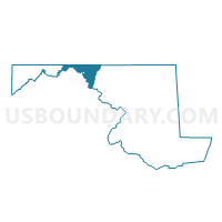
Washington Precinct 12-001, Washington County, Maryland
About
Outline

Summary
| Unique Area Identifier | 593183 |
| Name | Washington Precinct 12-001 |
| County | Washington County |
| State | Maryland |
| Area (square miles) | 17.92 |
| Land Area (square miles) | 17.72 |
| Water Area (square miles) | 0.19 |
| % of Land Area | 98.91 |
| % of Water Area | 1.09 |
| Latitude of the Internal Point | 39.53376310 |
| Longtitude of the Internal Point | -77.74855820 |
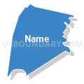
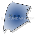
Maps


Graphs
Select a template below for downloading or customizing gragh for Washington Precinct 12-001, Washington County, Maryland


Neighbors
Neighoring Voting District (by Name) Neighboring Voting District on the Map
- Voting District 35, Jefferson County, WV
- Washington Precinct 01-001, Washington County, MD
- Washington Precinct 02-001, Washington County, MD
- Washington Precinct 06-001, Washington County, MD
- Washington Precinct 10-001, Washington County, MD
- Washington Precinct 10-002, Washington County, MD
- Washington Precinct 19-001, Washington County, MD
- Washington Precinct 20-001, Washington County, MD
Top 10 Neighboring County Subdivision (by Population) Neighboring County Subdivision on the Map
- District 10, Funkstown, Washington County, MD (12,166)
- Shepherdstown district, Jefferson County, WV (10,145)
- District 12, Fairplay, Washington County, MD (6,966)
- District 6, Boonsboro, Washington County, MD (6,116)
- District 2, Williamsport, Washington County, MD (4,366)
- District 1, Sharpsburg, Washington County, MD (3,286)
- District 19, Keedysville, Washington County, MD (2,519)
- District 20, Downsville, Washington County, MD (2,177)
Top 10 Neighboring Place (by Population) Neighboring Place on the Map
- St. James CDP, MD (2,953)
- Fairplay CDP, MD (580)
- Tilghmanton CDP, MD (465)
- Breathedsville CDP, MD (254)
- Mercersville CDP, MD (130)
- Bakersville CDP, MD (30)
Top 10 Neighboring Unified School District (by Population) Neighboring Unified School District on the Map
Top 10 Neighboring State Legislative District Lower Chamber (by Population) Neighboring State Legislative District Lower Chamber on the Map
- State Legislative Subdistrict 2A, MD (44,505)
- State Legislative Subdistrict 2B, MD (44,013)
- State House District 57, WV (21,709)
Top 10 Neighboring State Legislative District Upper Chamber (by Population) Neighboring State Legislative District Upper Chamber on the Map
Top 10 Neighboring 111th Congressional District (by Population) Neighboring 111th Congressional District on the Map
Top 10 Neighboring Census Tract (by Population) Neighboring Census Tract on the Map
- Census Tract 109, Washington County, MD (8,188)
- Census Tract 115, Washington County, MD (8,006)
- Census Tract 110, Washington County, MD (6,164)
- Census Tract 114, Washington County, MD (5,701)
- Census Tract 9722.01, Jefferson County, WV (4,679)
- Census Tract 116, Washington County, MD (2,896)
Top 10 Neighboring 5-Digit ZIP Code Tabulation Area (by Population) Neighboring 5-Digit ZIP Code Tabulation Area on the Map
- 21740, MD (61,859)
- 21713, MD (9,502)
- 21795, MD (9,233)
- 25443, WV (7,445)
- 21782, MD (4,097)
- 21756, MD (3,612)
- 21746, MD (1,883)
- 21733, MD (1,163)
- 21781, MD (136)