


Carroll Precinct 06-002, Carroll County, Maryland
About
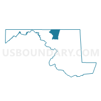
Outline

Summary
| Unique Area Identifier | 592221 |
| Name | Carroll Precinct 06-002 |
| County | Carroll County |
| State | Maryland |
| Area (square miles) | 18.77 |
| Land Area (square miles) | 18.74 |
| Water Area (square miles) | 0.04 |
| % of Land Area | 99.81 |
| % of Water Area | 0.19 |
| Latitude of the Internal Point | 39.66357800 |
| Longtitude of the Internal Point | -76.86423370 |
Maps

Graphs
Select a template below for downloading or customizing gragh for Carroll Precinct 06-002, Carroll County, Maryland


Neighbors
Neighoring Voting District (by Name) Neighboring Voting District on the Map
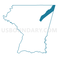
- Baltimore County Precinct 06-001, Baltimore County, MD
- Carroll Precinct 06-001, Carroll County, MD
- Carroll Precinct 07-002, Carroll County, MD
- Carroll Precinct 08-001, Carroll County, MD
- Carroll Precinct 08-002, Carroll County, MD
- CODORUS TWP DIST 01, York County, PA
- MANHEIM TWP Voting District, York County, PA
Top 10 Neighboring County Subdivision (by Population) Neighboring County Subdivision on the Map
- District 7, Westminster, Carroll County, MD (36,752)
- District 8, Hampstead, Carroll County, MD (14,798)
- District 6, Manchester, Carroll County, MD (14,001)
- District 6, Baltimore County, MD (5,789)
- Codorus township, York County, PA (3,796)
- Manheim township, York County, PA (3,380)
Top 10 Neighboring Place (by Population) Neighboring Place on the Map
Top 10 Neighboring Unified School District (by Population) Neighboring Unified School District on the Map
- Baltimore County Public Schools, MD (805,029)
- Carroll County Public Schools, MD (167,134)
- South Western School District, PA (26,736)
- Southern York County School District, PA (20,833)
Top 10 Neighboring State Legislative District Lower Chamber (by Population) Neighboring State Legislative District Lower Chamber on the Map
- State Legislative Subdistrict 5A, MD (86,686)
- State House District 93, PA (71,712)
- State Legislative Subdistrict 5B, MD (42,918)
Top 10 Neighboring State Legislative District Upper Chamber (by Population) Neighboring State Legislative District Upper Chamber on the Map
Top 10 Neighboring 111th Congressional District (by Population) Neighboring 111th Congressional District on the Map
Top 10 Neighboring Census Tract (by Population) Neighboring Census Tract on the Map
- Census Tract 5082, Carroll County, MD (7,133)
- Census Tract 4060, Baltimore County, MD (5,789)
- Census Tract 5062, Carroll County, MD (5,444)
- Census Tract 5076.01, Carroll County, MD (5,027)
- Census Tract 5081.01, Carroll County, MD (4,760)
- Census Tract 5061.01, Carroll County, MD (4,679)
- Census Tract 5076.02, Carroll County, MD (4,348)
- Census Tract 5061.02, Carroll County, MD (3,880)
- Census Tract 225, York County, PA (3,796)
- Census Tract 224.01, York County, PA (3,380)