


Precinct 70A, Tangipahoa Parish, Louisiana
About
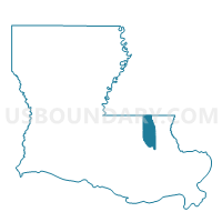
Outline

Summary
| Unique Area Identifier | 590992 |
| Name | Precinct 70A |
| County | Tangipahoa Parish |
| State | Louisiana |
| Area (square miles) | 0.56 |
| Land Area (square miles) | 0.56 |
| Water Area (square miles) | 0.00 |
| % of Land Area | 100.00 |
| % of Water Area | 0.00 |
| Latitude of the Internal Point | 30.45674670 |
| Longtitude of the Internal Point | -90.45132210 |
Maps


Graphs
Select a template below for downloading or customizing gragh for Precinct 70A, Tangipahoa Parish, Louisiana


Neighbors
Neighoring Voting District (by Name) Neighboring Voting District on the Map
- Precinct 139, Tangipahoa Parish, LA
- Precinct 70, Tangipahoa Parish, LA
- Precinct 72, Tangipahoa Parish, LA
- Precinct 72A, Tangipahoa Parish, LA
Top 10 Neighboring County Subdivision (by Population) Neighboring County Subdivision on the Map
- District 8, Tangipahoa Parish, LA (13,186)
- District 10, Tangipahoa Parish, LA (12,991)
- District 9, Tangipahoa Parish, LA (12,918)