


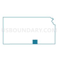
Falls Township Voting District, Sumner County, Kansas
About
Outline

Summary
| Unique Area Identifier | 587522 |
| Name | Falls Township Voting District |
| County | Sumner County |
| State | Kansas |
| Area (square miles) | 53.56 |
| Land Area (square miles) | 53.56 |
| Water Area (square miles) | 0.00 |
| % of Land Area | 100.00 |
| % of Water Area | 0.00 |
| Latitude of the Internal Point | 37.06313930 |
| Longtitude of the Internal Point | -97.52811530 |
Maps


Graphs
Select a template below for downloading or customizing gragh for Falls Township Voting District, Sumner County, Kansas


Neighbors
Neighoring Voting District (by Name) Neighboring Voting District on the Map
- Voting District 11, Grant County, OK
- Voting District 29, Grant County, OK
- Caldwell Township Voting District, Sumner County, KS
- Chikaskia Township Voting District, Sumner County, KS
- Downs Township Voting District, Sumner County, KS
- Jackson Township Voting District, Sumner County, KS
- South Haven Township Voting District, Sumner County, KS
Top 10 Neighboring County Subdivision (by Population) Neighboring County Subdivision on the Map
- Medford CCD, Grant County, OK (1,554)
- South Haven township, Sumner County, KS (567)
- Caldwell township, Sumner County, KS (157)
- Downs township, Sumner County, KS (156)
- Jackson township, Sumner County, KS (140)
- Falls township, Sumner County, KS (135)
- Chikaskia township, Sumner County, KS (59)
Top 10 Neighboring Unified School District (by Population) Neighboring Unified School District on the Map
- Caldwell Unified School District 360, KS (1,467)
- Deer Creek-Lamont Schools, OK (1,009)
- South Haven Unified School District 509, KS (879)
Top 10 Neighboring State Legislative District Lower Chamber (by Population) Neighboring State Legislative District Lower Chamber on the Map
- State House District 38, OK (32,291)
- State House District 79, KS (20,632)
- State House District 80, KS (20,532)