


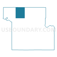
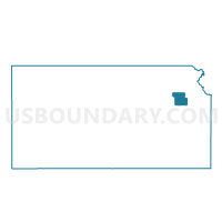
Grove Township Voting District, Shawnee County, Kansas
About
Outline

Summary
| Unique Area Identifier | 587291 |
| Name | Grove Township Voting District |
| County | Shawnee County |
| State | Kansas |
| Area (square miles) | 29.94 |
| Land Area (square miles) | 29.71 |
| Water Area (square miles) | 0.23 |
| % of Land Area | 99.24 |
| % of Water Area | 0.76 |
| Latitude of the Internal Point | 39.17024260 |
| Longtitude of the Internal Point | -95.85669440 |
Maps

Graphs
Select a template below for downloading or customizing gragh for Grove Township Voting District, Shawnee County, Kansas


Neighbors
Neighoring Voting District (by Name) Neighboring Voting District on the Map
- East Rossville Voting District, Shawnee County, KS
- East Silver Lake Voting District, Shawnee County, KS
- Kiro Voting District, Shawnee County, KS
- Messhoss Creek Voting District, Shawnee County, KS
- Washington Township Voting District, Jackson County, KS
- West Silver Lake Voting District, Shawnee County, KS
Top 10 Neighboring County Subdivision (by Population) Neighboring County Subdivision on the Map
- Silver Lake township, Shawnee County, KS (2,024)
- Rossville township, Shawnee County, KS (1,907)
- Menoken township, Shawnee County, KS (1,535)
- Grove township, Shawnee County, KS (696)
- Washington township, Jackson County, KS (582)
Top 10 Neighboring Unified School District (by Population) Neighboring Unified School District on the Map
- Kaw Valley Unified School District 321, KS (7,706)
- Royal Valley Unified School District 337, KS (4,513)
- Silver Lake Unified School District 372, KS (3,403)