


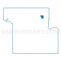
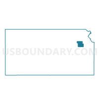
Sac Voting District, Shawnee County, Kansas
About
Outline

Summary
| Unique Area Identifier | 587285 |
| Name | Sac Voting District |
| County | Shawnee County |
| State | Kansas |
| Area (square miles) | 1.76 |
| Land Area (square miles) | 1.73 |
| Water Area (square miles) | 0.03 |
| % of Land Area | 98.36 |
| % of Water Area | 1.64 |
| Latitude of the Internal Point | 39.14779030 |
| Longtitude of the Internal Point | -95.65354520 |
Maps

Graphs
Select a template below for downloading or customizing gragh for Sac Voting District, Shawnee County, Kansas


Neighbors
Neighoring Voting District (by Name) Neighboring Voting District on the Map
- Elmont Voting District, Shawnee County, KS
- Fox Voting District, Shawnee County, KS
- Kilmer Voting District, Shawnee County, KS
- Pottawatomie Voting District, Shawnee County, KS
- Rochester Voting District, Shawnee County, KS
- Sherman Voting District, Shawnee County, KS