


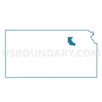
Bala Township Voting District, Riley County, Kansas
About
Outline

Summary
| Unique Area Identifier | 586549 |
| Name | Bala Township Voting District |
| County | Riley County |
| State | Kansas |
| Area (square miles) | 41.97 |
| Land Area (square miles) | 41.93 |
| Water Area (square miles) | 0.04 |
| % of Land Area | 99.91 |
| % of Water Area | 0.09 |
| Latitude of the Internal Point | 39.35412750 |
| Longtitude of the Internal Point | -96.89795430 |
Maps


Graphs
Select a template below for downloading or customizing gragh for Bala Township Voting District, Riley County, Kansas


Neighbors
Neighoring Voting District (by Name) Neighboring Voting District on the Map
- Fancy Creek Township Voting District, Riley County, KS
- Fort Riley A Madison Township Voting District, Riley County, KS
- Grant Township Voting District, Clay County, KS
- Highland Township Voting District, Clay County, KS
- Madison Township Voting District, Riley County, KS
- Sherman Township Voting District, Riley County, KS
Top 10 Neighboring County Subdivision (by Population) Neighboring County Subdivision on the Map
- Madison township, Riley County, KS (9,606)
- Bala township, Riley County, KS (735)
- Sherman township, Riley County, KS (579)
- Highland township, Clay County, KS (278)
- Grant township, Clay County, KS (146)
- Fancy Creek township, Riley County, KS (116)
Top 10 Neighboring Place (by Population) Neighboring Place on the Map
Top 10 Neighboring Unified School District (by Population) Neighboring Unified School District on the Map
- Clay Center Unified School District 379, KS (8,219)
- Riley County Unified School District 378, KS (4,492)
- Blue Valley Unified School District 384, KS (1,665)
Top 10 Neighboring State Legislative District Lower Chamber (by Population) Neighboring State Legislative District Lower Chamber on the Map
Top 10 Neighboring State Legislative District Upper Chamber (by Population) Neighboring State Legislative District Upper Chamber on the Map
Top 10 Neighboring 111th Congressional District (by Population) Neighboring 111th Congressional District on the Map
Top 10 Neighboring Census Tract (by Population) Neighboring Census Tract on the Map
- Census Tract 13.02, Riley County, KS (5,331)
- Census Tract 4581, Clay County, KS (3,894)
- Census Tract 9800, Riley County, KS (0)