


Sumner Township Voting District, Reno County, Kansas
About
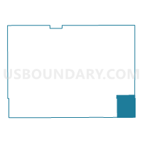
Outline

Summary
| Unique Area Identifier | 586415 |
| Name | Sumner Township Voting District |
| County | Reno County |
| State | Kansas |
| Area (square miles) | 43.45 |
| Land Area (square miles) | 40.60 |
| Water Area (square miles) | 2.85 |
| % of Land Area | 93.45 |
| % of Water Area | 6.55 |
| Latitude of the Internal Point | 37.78555130 |
| Longtitude of the Internal Point | -97.74521600 |
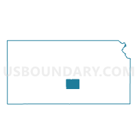
Maps

Graphs
Select a template below for downloading or customizing gragh for Sumner Township Voting District, Reno County, Kansas


Neighbors
Neighoring Voting District (by Name) Neighboring Voting District on the Map
- Evan Township Voting District, Kingman County, KS
- Garden Plain Voting District, Sedgwick County, KS
- Grand River Voting District, Sedgwick County, KS
- Greeley Voting District, Sedgwick County, KS
- Haven Township Voting District, Reno County, KS
- Ninnescah Township Voting District, Reno County, KS
- Sherman Voting District, Sedgwick County, KS
Top 10 Neighboring County Subdivision (by Population) Neighboring County Subdivision on the Map
- Garden Plain township, Sedgwick County, KS (1,838)
- Sherman township, Sedgwick County, KS (1,716)
- Haven township, Reno County, KS (1,649)
- Greeley township, Sedgwick County, KS (1,035)
- Sumner township, Reno County, KS (654)
- Grand River township, Sedgwick County, KS (603)
- Evan township, Kingman County, KS (542)
- Ninnescah township, Reno County, KS (226)
Top 10 Neighboring Unified School District (by Population) Neighboring Unified School District on the Map
- Renwick Unified School District 267, KS (8,364)
- Kingman-Norwich Unified School District 331, KS (6,228)
- Haven Public Schools Unified School District 312, KS (6,000)
- Cheney Unified School District 268, KS (3,555)
- Pretty Prairie Unified School District 311, KS (1,602)
Top 10 Neighboring State Legislative District Lower Chamber (by Population) Neighboring State Legislative District Lower Chamber on the Map
- State House District 90, KS (25,763)
- State House District 93, KS (25,269)
- State House District 101, KS (20,821)
Top 10 Neighboring State Legislative District Upper Chamber (by Population) Neighboring State Legislative District Upper Chamber on the Map
- State Senate District 26, KS (82,246)
- State Senate District 33, KS (64,554)
- State Senate District 34, KS (64,511)
Top 10 Neighboring 111th Congressional District (by Population) Neighboring 111th Congressional District on the Map
Top 10 Neighboring Census Tract (by Population) Neighboring Census Tract on the Map
- Census Tract 14, Reno County, KS (5,040)
- Census Tract 105, Sedgwick County, KS (4,130)
- Census Tract 106, Sedgwick County, KS (3,972)
- Census Tract 9611, Kingman County, KS (2,522)
- Census Tract 104, Sedgwick County, KS (2,240)
- Census Tract 18, Reno County, KS (2,081)