


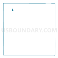
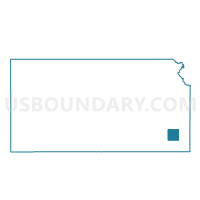
Chanute Ward 1, Neosho County, Kansas
About
Outline

Summary
| Unique Area Identifier | 586116 |
| Name | Chanute Ward 1 |
| County | Neosho County |
| State | Kansas |
| Area (square miles) | 0.28 |
| Land Area (square miles) | 0.28 |
| Water Area (square miles) | 0.00 |
| % of Land Area | 100.00 |
| % of Water Area | 0.00 |
| Latitude of the Internal Point | 37.68647800 |
| Longtitude of the Internal Point | -95.44801610 |
Maps

Graphs
Select a template below for downloading or customizing gragh for Chanute Ward 1, Neosho County, Kansas


Neighbors
Neighoring Voting District (by Name) Neighboring Voting District on the Map
- Chanute Ward 2 Precinct 1, Neosho County, KS
- Chanute Ward 3 Precinct 1, Neosho County, KS
- Chanute Ward 4 Precinct 1, Neosho County, KS
- Chanute Ward 4 Precinct 2, Neosho County, KS
- North Tioga Township Voting District, Neosho County, KS
- South Tioga East Township Voting District, Neosho County, KS