


Dighton Township 3, Lane County, Kansas
About
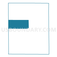
Outline

Summary
| Unique Area Identifier | 585614 |
| Name | Dighton Township 3 |
| County | Lane County |
| State | Kansas |
| Area (square miles) | 59.51 |
| Land Area (square miles) | 59.51 |
| Water Area (square miles) | 0.00 |
| % of Land Area | 100.00 |
| % of Water Area | 0.00 |
| Latitude of the Internal Point | 38.51849520 |
| Longtitude of the Internal Point | -100.57749580 |
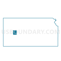
Maps

Graphs
Select a template below for downloading or customizing gragh for Dighton Township 3, Lane County, Kansas


Neighbors
Neighoring Voting District (by Name) Neighboring Voting District on the Map
- Cheyenne Township Voting District, Lane County, KS
- Dighton City Precinct 2, Lane County, KS
- Dighton City Precinct 3, Lane County, KS
- Dighton Township 1 Voting District, Lane County, KS
- Dighton Township 2 Voting District, Lane County, KS
- Keystone Township Voting District, Scott County, KS
- Michigan Township Voting District, Scott County, KS
- Wilson Township Voting District, Lane County, KS
Top 10 Neighboring County Subdivision (by Population) Neighboring County Subdivision on the Map
- Dighton township, Lane County, KS (1,268)
- Cheyenne township, Lane County, KS (314)
- Keystone township, Scott County, KS (98)
- Michigan township, Scott County, KS (89)
- Wilson township, Lane County, KS (59)
Top 10 Neighboring Place (by Population) Neighboring Place on the Map
Top 10 Neighboring Unified School District (by Population) Neighboring Unified School District on the Map
- Scott County Unified School District 466, KS (4,947)
- Dighton Unified School District 482, KS (1,443)
- Healy Public Schools Unified School District 468, KS (342)