


Chetopa Ward 2, Labette County, Kansas
About
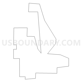
Outline
Summary
| Unique Area Identifier | 585604 |
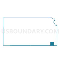
| Name | Chetopa Ward 2 |
| County | Labette County |
| State | Kansas |
| Area (square miles) | 0.50 |
| Land Area (square miles) | 0.42 |
| Water Area (square miles) | 0.08 |
| % of Land Area | 84.27 |
| % of Water Area | 15.73 |
| Latitude of the Internal Point | 37.03818240 |
| Longtitude of the Internal Point | -95.08283980 |
Maps

Graphs
Select a template below for downloading or customizing gragh for Chetopa Ward 2, Labette County, Kansas


Neighbors
Neighoring Voting District (by Name) Neighboring Voting District on the Map
- Chetopa Ward 1, Labette County, KS
- Chetopa Ward 3, Labette County, KS
- Neosho Township Melrose Voting District, Cherokee County, KS
- Richland Township Voting District, Labette County, KS
Top 10 Neighboring County Subdivision (by Population) Neighboring County Subdivision on the Map
- Chetopa city, Labette County, KS (1,125)
- Richland township, Labette County, KS (287)
- Neosho township, Cherokee County, KS (279)
Top 10 Neighboring Place (by Population) Neighboring Place on the Map
Top 10 Neighboring Unified School District (by Population) Neighboring Unified School District on the Map
- Columbus Unified School District 493, KS (7,571)
- Chetopa-St. Paul Unified School District 505, KS (2,652)