


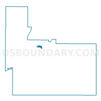
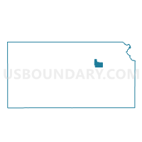
Fort Riley Precinct J, Geary County, Kansas
About
Outline

Summary
| Unique Area Identifier | 584862 |
| Name | Fort Riley Precinct J |
| County | Geary County |
| State | Kansas |
| Area (square miles) | 0.52 |
| Land Area (square miles) | 0.46 |
| Water Area (square miles) | 0.06 |
| % of Land Area | 87.71 |
| % of Water Area | 12.29 |
| Latitude of the Internal Point | 39.05995780 |
| Longtitude of the Internal Point | -96.78249780 |
Maps

Graphs
Select a template below for downloading or customizing gragh for Fort Riley Precinct J, Geary County, Kansas


Neighbors
Neighoring Voting District (by Name) Neighboring Voting District on the Map
- Fort Riley Precinct B, Geary County, KS
- Fort Riley Precinct G, Geary County, KS
- Fort Riley Precinct I, Geary County, KS
- Fort Riley Precinct K, Geary County, KS
- Grandview Township Voting District, Geary County, KS
- Junction City Ward 4 Precinct 1, Geary County, KS
- Marshall Field Voting District, Geary County, KS
Top 10 Neighboring County Subdivision (by Population) Neighboring County Subdivision on the Map
- Junction City city, Geary County, KS (23,353)
- Smoky Hill township, Geary County, KS (6,531)
- Jefferson township, Geary County, KS (2,041)