


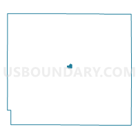
Girard Ward 2, Crawford County, Kansas
About
Outline

Summary
| Unique Area Identifier | 584449 |
| Name | Girard Ward 2 |
| County | Crawford County |
| State | Kansas |
| Area (square miles) | 0.54 |
| Land Area (square miles) | 0.53 |
| Water Area (square miles) | 0.01 |
| % of Land Area | 98.35 |
| % of Water Area | 1.65 |
| Latitude of the Internal Point | 37.51535720 |
| Longtitude of the Internal Point | -94.85081820 |
Maps

Graphs
Select a template below for downloading or customizing gragh for Girard Ward 2, Crawford County, Kansas


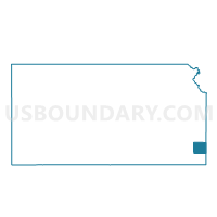
Neighbors
Neighoring Voting District (by Name) Neighboring Voting District on the Map
- Crawford Voting District, Crawford County, KS
- Girard Ward 1, Crawford County, KS
- Girard Ward 3, Crawford County, KS
- Girard Ward 4, Crawford County, KS