


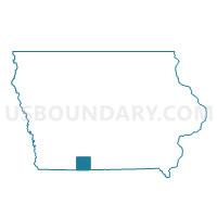
LIBERTY TWP Voting District, Ringgold County, Iowa
About
Outline

Summary
| Unique Area Identifier | 583328 |
| Name | LIBERTY TWP Voting District |
| County | Ringgold County |
| State | Iowa |
| Area (square miles) | 35.59 |
| Land Area (square miles) | 35.31 |
| Water Area (square miles) | 0.28 |
| % of Land Area | 99.21 |
| % of Water Area | 0.79 |
| Latitude of the Internal Point | 40.77172400 |
| Longtitude of the Internal Point | -94.18970180 |
Maps


Graphs
Select a template below for downloading or customizing gragh for LIBERTY TWP Voting District, Ringgold County, Iowa


Neighbors
Neighoring Voting District (by Name) Neighboring Voting District on the Map
- ATHENS TWP Voting District, Ringgold County, IA
- JEFFERSON TWP W/O DIAGONAL & SHANNON CITY Voting District, Ringgold County, IA
- MONROE TWP W/O BEACONSFIELD Voting District, Ringgold County, IA
- MOUNT AYR W/RICE TWP PART Voting District, Ringgold County, IA
- POE TWP Voting District, Ringgold County, IA
- TINGLEY TWP Voting District, Ringgold County, IA
- UNION TWP W/O BEACONSFIELD Voting District, Ringgold County, IA
- WASHINGTON TWP W/O DIAGONAL Voting District, Ringgold County, IA
Top 10 Neighboring County Subdivision (by Population) Neighboring County Subdivision on the Map
- Mount Ayr city, Ringgold County, IA (1,691)
- Washington township, Ringgold County, IA (525)
- Athens township, Ringgold County, IA (434)
- Tingley township, Ringgold County, IA (327)
- Union township, Ringgold County, IA (286)
- Poe township, Ringgold County, IA (169)
- Liberty township, Ringgold County, IA (152)
- Jefferson township, Ringgold County, IA (149)
- Monroe township, Ringgold County, IA (111)