


CLARINDA Voting District, Page County, Iowa
About
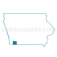
Outline

Summary
| Unique Area Identifier | 582992 |
| Name | CLARINDA Voting District |
| County | Page County |
| State | Iowa |
| Area (square miles) | 5.22 |
| Land Area (square miles) | 5.19 |
| Water Area (square miles) | 0.03 |
| % of Land Area | 99.37 |
| % of Water Area | 0.63 |
| Latitude of the Internal Point | 40.73770640 |
| Longtitude of the Internal Point | -95.03416260 |
Maps


Graphs
Select a template below for downloading or customizing gragh for CLARINDA Voting District, Page County, Iowa


Neighbors
Neighoring Voting District (by Name) Neighboring Voting District on the Map
- EAST RIVER TWP W/O CLARINDA Voting District, Page County, IA
- HARLAN TWP W/O CLARINDA & SHAMBAUGH Voting District, Page County, IA
- NODAWAY TWP W/O CLARINDA & YORKTOWN Voting District, Page County, IA
Top 10 Neighboring County Subdivision (by Population) Neighboring County Subdivision on the Map
- Nodaway township, Page County, IA (6,148)
- Harlan township, Page County, IA (391)
- East River township, Page County, IA (254)
Top 10 Neighboring Place (by Population) Neighboring Place on the Map
Top 10 Neighboring Unified School District (by Population) Neighboring Unified School District on the Map
Top 10 Neighboring State Legislative District Lower Chamber (by Population) Neighboring State Legislative District Lower Chamber on the Map
Top 10 Neighboring State Legislative District Upper Chamber (by Population) Neighboring State Legislative District Upper Chamber on the Map
Top 10 Neighboring 111th Congressional District (by Population) Neighboring 111th Congressional District on the Map
Top 10 Neighboring Census Tract (by Population) Neighboring Census Tract on the Map
- Census Tract 4904, Page County, IA (3,458)
- Census Tract 4901, Page County, IA (2,624)
- Census Tract 4906, Page County, IA (2,334)
- Census Tract 4905, Page County, IA (2,236)