


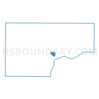
MUSCATINE PCT 6, Muscatine County, Iowa
About
Outline

Summary
| Unique Area Identifier | 582933 |
| Name | MUSCATINE PCT 6 |
| County | Muscatine County |
| State | Iowa |
| Area (square miles) | 1.50 |
| Land Area (square miles) | 1.50 |
| Water Area (square miles) | 0.00 |
| % of Land Area | 100.00 |
| % of Water Area | 0.00 |
| Latitude of the Internal Point | 41.44611490 |
| Longtitude of the Internal Point | -91.05483940 |
Maps


Graphs
Select a template below for downloading or customizing gragh for MUSCATINE PCT 6, Muscatine County, Iowa


Neighbors
Neighoring Voting District (by Name) Neighboring Voting District on the Map
- BLOOMINGTON TWP W/O MUSCATINE Voting District, Muscatine County, IA
- MUSCATINE PCT 1, Muscatine County, IA
- MUSCATINE PCT 10, Muscatine County, IA
- MUSCATINE PCT 5, Muscatine County, IA