


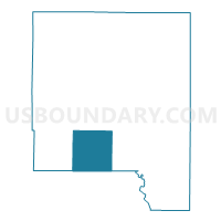
SHARON TWP Voting District, Johnson County, Iowa
About
Outline

Summary
| Unique Area Identifier | 582488 |
| Name | SHARON TWP Voting District |
| County | Johnson County |
| State | Iowa |
| Area (square miles) | 36.27 |
| Land Area (square miles) | 36.26 |
| Water Area (square miles) | 0.01 |
| % of Land Area | 99.98 |
| % of Water Area | 0.02 |
| Latitude of the Internal Point | 41.55810610 |
| Longtitude of the Internal Point | -91.64635710 |
Maps

Graphs
Select a template below for downloading or customizing gragh for SHARON TWP Voting District, Johnson County, Iowa


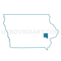
Neighbors
Neighoring Voting District (by Name) Neighboring Voting District on the Map
- ENGLISH RIVER TWP Voting District, Washington County, IA
- IOWA TWP Voting District, Washington County, IA
- LIBERTY TWP PART W/O HILLS Voting District, Johnson County, IA
- UNION TWP W/O CORALVILLE Voting District, Johnson County, IA
- WASHINGTON TWP Voting District, Johnson County, IA
Top 10 Neighboring County Subdivision (by Population) Neighboring County Subdivision on the Map
- English River township, Washington County, IA (3,924)
- Iowa township, Washington County, IA (2,262)
- Sharon township, Johnson County, IA (1,291)
- Washington township, Johnson County, IA (1,200)
- Liberty township, Johnson County, IA (1,104)
- Union township, Johnson County, IA (659)
Top 10 Neighboring Unified School District (by Population) Neighboring Unified School District on the Map
- Iowa City Community School District, IA (105,355)
- Mid-Prairie Community School District, IA (9,085)
- Highland Community School District, IA (3,719)