


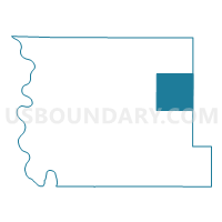
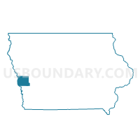
DOUGLAS TWP Voting District, Harrison County, Iowa
About
Outline

Summary
| Unique Area Identifier | 582301 |
| Name | DOUGLAS TWP Voting District |
| County | Harrison County |
| State | Iowa |
| Area (square miles) | 36.15 |
| Land Area (square miles) | 36.05 |
| Water Area (square miles) | 0.10 |
| % of Land Area | 99.73 |
| % of Water Area | 0.27 |
| Latitude of the Internal Point | 41.73909400 |
| Longtitude of the Internal Point | -95.61777480 |
Maps

Graphs
Select a template below for downloading or customizing gragh for DOUGLAS TWP Voting District, Harrison County, Iowa


Neighbors
Neighoring Voting District (by Name) Neighboring Voting District on the Map
- BOYER TWP Voting District, Harrison County, IA
- CASS TWP Voting District, Harrison County, IA
- CASS TWP Voting District, Shelby County, IA
- GROVE TWP Voting District, Shelby County, IA
- HARRISON TWP W/O DUNLAP Voting District, Harrison County, IA
- JEFFERSON TWP Voting District, Harrison County, IA
- LINCOLN TWP Voting District, Harrison County, IA
- WASHINGTON TWP Voting District, Shelby County, IA
Top 10 Neighboring County Subdivision (by Population) Neighboring County Subdivision on the Map
- Jefferson township, Harrison County, IA (2,008)
- Boyer township, Harrison County, IA (1,875)
- Harrison township, Harrison County, IA (1,300)
- Washington township, Shelby County, IA (456)
- Cass township, Shelby County, IA (447)
- Cass township, Harrison County, IA (236)
- Douglas township, Harrison County, IA (193)
- Grove township, Shelby County, IA (173)
- Lincoln township, Harrison County, IA (146)
Top 10 Neighboring Unified School District (by Population) Neighboring Unified School District on the Map
- Harlan Community School District, IA (8,688)
- Boyer Valley Community School District, IA (2,699)
- Woodbine Community School District, IA (2,467)
Top 10 Neighboring State Legislative District Lower Chamber (by Population) Neighboring State Legislative District Lower Chamber on the Map
Top 10 Neighboring State Legislative District Upper Chamber (by Population) Neighboring State Legislative District Upper Chamber on the Map
Top 10 Neighboring 111th Congressional District (by Population) Neighboring 111th Congressional District on the Map
Top 10 Neighboring Census Tract (by Population) Neighboring Census Tract on the Map
- Census Tract 2902, Harrison County, IA (3,491)
- Census Tract 9602, Shelby County, IA (3,104)
- Census Tract 2903, Harrison County, IA (3,044)
- Census Tract 2901, Harrison County, IA (2,547)