


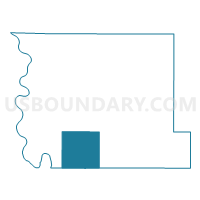
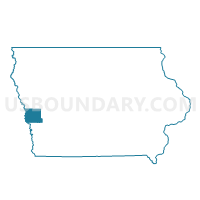
ST. JOHN TWP Voting District, Harrison County, Iowa
About
Outline

Summary
| Unique Area Identifier | 582287 |
| Name | ST. JOHN TWP Voting District |
| County | Harrison County |
| State | Iowa |
| Area (square miles) | 45.85 |
| Land Area (square miles) | 45.66 |
| Water Area (square miles) | 0.19 |
| % of Land Area | 99.59 |
| % of Water Area | 0.41 |
| Latitude of the Internal Point | 41.55375400 |
| Longtitude of the Internal Point | -95.89530880 |
Maps

Graphs
Select a template below for downloading or customizing gragh for ST. JOHN TWP Voting District, Harrison County, Iowa


Neighbors
Neighoring Voting District (by Name) Neighboring Voting District on the Map
- BOOMER TWP Voting District, Pottawattamie County, IA
- CALHOUN TWP Voting District, Harrison County, IA
- CINCINNATI TWP Voting District, Harrison County, IA
- LA GRANGE TWP Voting District, Harrison County, IA
- ROCKFORD TWP Voting District, Pottawattamie County, IA
- TAYLOR TWP W/O MODALE Voting District, Harrison County, IA
Top 10 Neighboring County Subdivision (by Population) Neighboring County Subdivision on the Map
- St. John township, Harrison County, IA (4,055)
- Boomer township, Pottawattamie County, IA (681)
- Rockford township, Pottawattamie County, IA (632)
- Taylor township, Harrison County, IA (516)
- La Grange township, Harrison County, IA (475)
- Calhoun township, Harrison County, IA (362)
- Cincinnati township, Harrison County, IA (197)
Top 10 Neighboring Place (by Population) Neighboring Place on the Map
Top 10 Neighboring Unified School District (by Population) Neighboring Unified School District on the Map
- Missouri Valley Community School District, IA (5,332)
- Logan-Magnolia Community School District, IA (3,163)
- West Harrison Community School District, IA (2,700)
Top 10 Neighboring State Legislative District Lower Chamber (by Population) Neighboring State Legislative District Lower Chamber on the Map
Top 10 Neighboring State Legislative District Upper Chamber (by Population) Neighboring State Legislative District Upper Chamber on the Map
Top 10 Neighboring 111th Congressional District (by Population) Neighboring 111th Congressional District on the Map
Top 10 Neighboring Census Tract (by Population) Neighboring Census Tract on the Map
- Census Tract 214, Pottawattamie County, IA (3,589)
- Census Tract 2904, Harrison County, IA (3,324)
- Census Tract 2903, Harrison County, IA (3,044)
- Census Tract 2905, Harrison County, IA (2,522)