


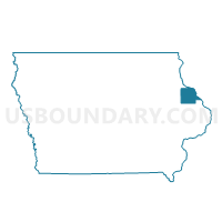
ZWINGLE IN DUBUQUE COUNTY Voting District, Dubuque County, Iowa
About
Outline

Summary
| Unique Area Identifier | 582052 |
| Name | ZWINGLE IN DUBUQUE COUNTY Voting District |
| County | Dubuque County |
| State | Iowa |
| Area (square miles) | 0.14 |
| Land Area (square miles) | 0.14 |
| Water Area (square miles) | 0.00 |
| % of Land Area | 100.00 |
| % of Water Area | 0.00 |
| Latitude of the Internal Point | 42.29751080 |
| Longtitude of the Internal Point | -90.68736120 |
Maps


Graphs
Select a template below for downloading or customizing gragh for ZWINGLE IN DUBUQUE COUNTY Voting District, Dubuque County, Iowa


Neighbors
Neighoring Voting District (by Name) Neighboring Voting District on the Map
- OTTER CREEK TWP W/O ZWINGLE Voting District, Jackson County, IA
- WASHINGTON TWP W/O ZWINGLE Voting District, Dubuque County, IA
- ZWINGLE IN JACKSON COUNTY Voting District, Jackson County, IA