


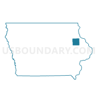
DELAWARE Voting District, Delaware County, Iowa
About
Outline

Summary
| Unique Area Identifier | 581964 |
| Name | DELAWARE Voting District |
| County | Delaware County |
| State | Iowa |
| Area (square miles) | 0.81 |
| Land Area (square miles) | 0.80 |
| Water Area (square miles) | 0.01 |
| % of Land Area | 98.64 |
| % of Water Area | 1.36 |
| Latitude of the Internal Point | 42.47086450 |
| Longtitude of the Internal Point | -91.34051050 |
Maps


Graphs
Select a template below for downloading or customizing gragh for DELAWARE Voting District, Delaware County, Iowa


Neighbors
Neighoring Voting District (by Name) Neighboring Voting District on the Map
- DELHI TWP W/O DELAWARE Voting District, Delaware County, IA
- ONEIDA TWP W/O DELAWARE Voting District, Delaware County, IA