


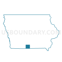
LEON Voting District, Decatur County, Iowa
About
Outline

Summary
| Unique Area Identifier | 581941 |
| Name | LEON Voting District |
| County | Decatur County |
| State | Iowa |
| Area (square miles) | 3.18 |
| Land Area (square miles) | 3.17 |
| Water Area (square miles) | 0.01 |
| % of Land Area | 99.73 |
| % of Water Area | 0.27 |
| Latitude of the Internal Point | 40.74134090 |
| Longtitude of the Internal Point | -93.75557130 |
Maps


Graphs
Select a template below for downloading or customizing gragh for LEON Voting District, Decatur County, Iowa


Neighbors
Neighoring Voting District (by Name) Neighboring Voting District on the Map
Top 10 Neighboring County Subdivision (by Population) Neighboring County Subdivision on the Map
- Leon city, Decatur County, IA (1,977)
- Eden township, Decatur County, IA (282)
- Center township, Decatur County, IA (264)