


WILLIAMS TWP Voting District, Calhoun County, Iowa
About
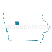
Outline

Summary
| Unique Area Identifier | 581643 |
| Name | WILLIAMS TWP Voting District |
| County | Calhoun County |
| State | Iowa |
| Area (square miles) | 35.80 |
| Land Area (square miles) | 35.75 |
| Water Area (square miles) | 0.05 |
| % of Land Area | 99.87 |
| % of Water Area | 0.13 |
| Latitude of the Internal Point | 42.51021810 |
| Longtitude of the Internal Point | -94.86034410 |
Maps


Graphs
Select a template below for downloading or customizing gragh for WILLIAMS TWP Voting District, Calhoun County, Iowa


Neighbors
Neighoring Voting District (by Name) Neighboring Voting District on the Map
- BUTLER TWP W/O POMEROY Voting District, Calhoun County, IA
- CEDAR TWP Voting District, Pocahontas County, IA
- CEDAR TWP W/O LYTTON Voting District, Sac County, IA
- COLFAX TWP Voting District, Pocahontas County, IA
- DOUGLAS TWP Voting District, Sac County, IA
- GARFIELD TWP W/O LYTTON Voting District, Calhoun County, IA
- NEWELL TWP Voting District, Buena Vista County, IA
Top 10 Neighboring County Subdivision (by Population) Neighboring County Subdivision on the Map
- Newell township, Buena Vista County, IA (1,125)
- Butler township, Calhoun County, IA (873)
- Cedar township, Pocahontas County, IA (755)
- Cedar township, Sac County, IA (480)
- Garfield township, Calhoun County, IA (189)
- Colfax township, Pocahontas County, IA (157)
- Williams township, Calhoun County, IA (132)
- Douglas township, Sac County, IA (132)
Top 10 Neighboring Unified School District (by Population) Neighboring Unified School District on the Map
- Rockwell City-Lytton Community School District, IA (3,084)
- Sac Community School District, IA (2,765)
- Newell-Fonda Community School District, IA (2,463)
- Pomeroy-Palmer Community School District, IA (1,528)
Top 10 Neighboring State Legislative District Lower Chamber (by Population) Neighboring State Legislative District Lower Chamber on the Map
- State House District 52, IA (28,211)
- State House District 8, IA (26,866)
- State House District 50, IA (25,121)
Top 10 Neighboring State Legislative District Upper Chamber (by Population) Neighboring State Legislative District Upper Chamber on the Map
- State Senate District 26, IA (55,929)
- State Senate District 25, IA (54,046)
- State Senate District 4, IA (53,582)
Top 10 Neighboring 111th Congressional District (by Population) Neighboring 111th Congressional District on the Map
Top 10 Neighboring Census Tract (by Population) Neighboring Census Tract on the Map
- Census Tract 9502, Calhoun County, IA (3,107)
- Census Tract 801, Sac County, IA (2,640)
- Census Tract 7803, Pocahontas County, IA (2,186)
- Census Tract 9603, Buena Vista County, IA (1,940)
Top 10 Neighboring 5-Digit ZIP Code Tabulation Area (by Population) Neighboring 5-Digit ZIP Code Tabulation Area on the Map
- 50583, IA (2,855)
- 50568, IA (1,398)
- 50540, IA (1,022)
- 50575, IA (969)
- 50561, IA (520)
- 50551, IA (158)