


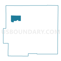
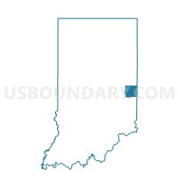
JEFFERSON 03, Wayne County, Indiana
About
Outline

Summary
| Unique Area Identifier | 581209 |
| Name | JEFFERSON 03 |
| County | Wayne County |
| State | Indiana |
| Area (square miles) | 7.92 |
| Land Area (square miles) | 7.91 |
| Water Area (square miles) | 0.01 |
| % of Land Area | 99.88 |
| % of Water Area | 0.12 |
| Latitude of the Internal Point | 39.93062350 |
| Longtitude of the Internal Point | -85.13223730 |
Maps

Graphs
Select a template below for downloading or customizing gragh for JEFFERSON 03, Wayne County, Indiana


Neighbors
Neighoring Voting District (by Name) Neighboring Voting District on the Map
- CLAY 01, Wayne County, IN
- DALTON 01, Wayne County, IN
- JEFFERSON 01, Wayne County, IN
- JEFFERSON 02, Wayne County, IN
- PERRY 01, Wayne County, IN
Top 10 Neighboring County Subdivision (by Population) Neighboring County Subdivision on the Map
- Jefferson township, Wayne County, IN (3,482)
- Clay township, Wayne County, IN (1,169)
- Perry township, Wayne County, IN (835)
- Dalton township, Wayne County, IN (566)