


PIGEON, Warrick County, Indiana
About
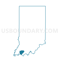
Outline

Summary
| Unique Area Identifier | 581128 |
| Name | PIGEON |
| County | Warrick County |
| State | Indiana |
| Area (square miles) | 40.58 |
| Land Area (square miles) | 40.47 |
| Water Area (square miles) | 0.11 |
| % of Land Area | 99.73 |
| % of Water Area | 0.27 |
| Latitude of the Internal Point | 38.17298650 |
| Longtitude of the Internal Point | -87.07704110 |
Maps


Graphs
Select a template below for downloading or customizing gragh for PIGEON, Warrick County, Indiana


Neighbors
Neighoring Voting District (by Name) Neighboring Voting District on the Map
- CARTER 02, Spencer County, IN
- CARTER 03, Spencer County, IN
- CASS 03, Dubois County, IN
- CLAY 01, Spencer County, IN
- JACKSON, Spencer County, IN
- LANE, Warrick County, IN
- LOCKHART, Pike County, IN
- OWEN, Warrick County, IN
- SKELTON 01, Warrick County, IN
Top 10 Neighboring County Subdivision (by Population) Neighboring County Subdivision on the Map
- Carter township, Spencer County, IN (3,258)
- Clay township, Spencer County, IN (2,801)
- Cass township, Dubois County, IN (2,115)
- Skelton township, Warrick County, IN (1,625)
- Pigeon township, Warrick County, IN (979)
- Lockhart township, Pike County, IN (907)
- Jackson township, Spencer County, IN (891)
- Owen township, Warrick County, IN (611)
- Lane township, Warrick County, IN (281)
Top 10 Neighboring Unified School District (by Population) Neighboring Unified School District on the Map
- Warrick County School Corporation, IN (59,689)
- Pike County School Corporation, IN (12,845)
- North Spencer County School Corporation, IN (12,043)
- Southwest Dubois County School Corporation, IN (9,642)
Top 10 Neighboring State Legislative District Lower Chamber (by Population) Neighboring State Legislative District Lower Chamber on the Map
Top 10 Neighboring State Legislative District Upper Chamber (by Population) Neighboring State Legislative District Upper Chamber on the Map
Top 10 Neighboring 111th Congressional District (by Population) Neighboring 111th Congressional District on the Map
Top 10 Neighboring Census Tract (by Population) Neighboring Census Tract on the Map
- Census Tract 9527, Spencer County, IN (7,643)
- Census Tract 9537, Dubois County, IN (7,258)
- Census Tract 301, Warrick County, IN (3,521)
- Census Tract 9539, Pike County, IN (3,445)
- Census Tract 9529, Spencer County, IN (2,666)
Top 10 Neighboring 5-Digit ZIP Code Tabulation Area (by Population) Neighboring 5-Digit ZIP Code Tabulation Area on the Map
- 47523, IN (3,435)
- 47637, IN (1,507)
- 47541, IN (1,224)
- 47537, IN (826)
- 47585, IN (592)
- 47552, IN (182)