


JORDAN, Warren County, Indiana
About
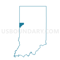
Outline

Summary
| Unique Area Identifier | 581095 |
| Name | JORDAN |
| County | Warren County |
| State | Indiana |
| Area (square miles) | 40.56 |
| Land Area (square miles) | 40.55 |
| Water Area (square miles) | 0.02 |
| % of Land Area | 99.96 |
| % of Water Area | 0.04 |
| Latitude of the Internal Point | 40.35122330 |
| Longtitude of the Internal Point | -87.46543590 |
Maps


Graphs
Select a template below for downloading or customizing gragh for JORDAN, Warren County, Indiana


Neighbors
Neighoring Voting District (by Name) Neighboring Voting District on the Map
- GRANT 5 Voting District, Vermilion County, IL
- LIBERTY, Warren County, IN
- PIKE, Warren County, IN
- PRAIRIE, Warren County, IN
- ROSS 2 Voting District, Vermilion County, IL
- SOUTH ROSS 1 Voting District, Vermilion County, IL
- STEUBEN, Warren County, IN
Top 10 Neighboring County Subdivision (by Population) Neighboring County Subdivision on the Map
- Grant township, Vermilion County, IL (6,028)
- Ross township, Vermilion County, IL (1,617)
- Pike township, Warren County, IN (1,221)
- South Ross township, Vermilion County, IL (1,070)
- Liberty township, Warren County, IN (896)
- Steuben township, Warren County, IN (487)
- Prairie township, Warren County, IN (257)
- Jordan township, Warren County, IN (247)
Top 10 Neighboring Unified School District (by Population) Neighboring Unified School District on the Map
- Benton Community School Corporation, IN (11,050)
- Warren County Metropolitan School District, IN (7,369)
- Rossville-Alvin Community Unit School District 7, IL (2,390)
Top 10 Neighboring State Legislative District Lower Chamber (by Population) Neighboring State Legislative District Lower Chamber on the Map
- State House District 105, IL (109,839)
- State House District 104, IL (105,087)
- State House District 42, IN (58,863)
Top 10 Neighboring State Legislative District Upper Chamber (by Population) Neighboring State Legislative District Upper Chamber on the Map
- State Senate District 53, IL (226,526)
- State Senate District 52, IL (219,424)
- State Senate District 38, IN (121,551)
Top 10 Neighboring 111th Congressional District (by Population) Neighboring 111th Congressional District on the Map
Top 10 Neighboring Census Tract (by Population) Neighboring Census Tract on the Map
- Census Tract 103, Vermilion County, IL (4,810)
- Census Tract 9511, Warren County, IN (3,762)
- Census Tract 101, Vermilion County, IL (3,306)