


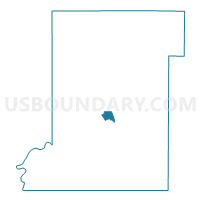
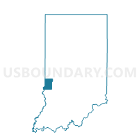
HONEY CREEK-D, Vigo County, Indiana
About
Outline

Summary
| Unique Area Identifier | 581021 |
| Name | HONEY CREEK-D |
| County | Vigo County |
| State | Indiana |
| Area (square miles) | 1.37 |
| Land Area (square miles) | 1.37 |
| Water Area (square miles) | 0.00 |
| % of Land Area | 100.00 |
| % of Water Area | 0.00 |
| Latitude of the Internal Point | 39.40405660 |
| Longtitude of the Internal Point | -87.39021930 |
Maps

Graphs
Select a template below for downloading or customizing gragh for HONEY CREEK-D, Vigo County, Indiana


Neighbors
Neighoring Voting District (by Name) Neighboring Voting District on the Map
- 09-A, Vigo County, IN
- HONEY CREEK-C, Vigo County, IN
- HONEY CREEK-F, Vigo County, IN
- HONEY CREEK-G, Vigo County, IN
- HONEY CREEK-H, Vigo County, IN