


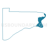
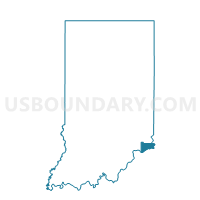
POSEY 01, Switzerland County, Indiana
About
Outline

Summary
| Unique Area Identifier | 580703 |
| Name | POSEY 01 |
| County | Switzerland County |
| State | Indiana |
| Area (square miles) | 13.33 |
| Land Area (square miles) | 12.22 |
| Water Area (square miles) | 1.11 |
| % of Land Area | 91.68 |
| % of Water Area | 8.32 |
| Latitude of the Internal Point | 38.83308660 |
| Longtitude of the Internal Point | -84.84469720 |
Maps

Graphs
Select a template below for downloading or customizing gragh for POSEY 01, Switzerland County, Indiana


Neighbors
Neighoring Voting District (by Name) Neighboring Voting District on the Map
Top 10 Neighboring County Subdivision (by Population) Neighboring County Subdivision on the Map
- Walton CCD, Boone County, KY (19,104)
- Warsaw CCD, Gallatin County, KY (8,589)
- Posey township, Switzerland County, IN (1,779)
- York township, Switzerland County, IN (1,206)
Top 10 Neighboring Place (by Population) Neighboring Place on the Map
Top 10 Neighboring Unified School District (by Population) Neighboring Unified School District on the Map
- Boone County School District, KY (112,752)
- Switzerland County School Corporation, IN (10,613)
- Gallatin County School District, KY (8,589)
Top 10 Neighboring State Legislative District Lower Chamber (by Population) Neighboring State Legislative District Lower Chamber on the Map
- State House District 68, IN (65,442)
- State House District 60, KY (61,922)
- State House District 61, KY (44,092)
Top 10 Neighboring State Legislative District Upper Chamber (by Population) Neighboring State Legislative District Upper Chamber on the Map
Top 10 Neighboring 111th Congressional District (by Population) Neighboring 111th Congressional District on the Map
Top 10 Neighboring Census Tract (by Population) Neighboring Census Tract on the Map
- Census Tract 9601.01, Gallatin County, KY (6,176)
- Census Tract 9657, Switzerland County, IN (4,414)
- Census Tract 706.01, Boone County, KY (2,593)
- Census Tract 9601.02, Gallatin County, KY (2,413)