


NORTH BEND, Starke County, Indiana
About
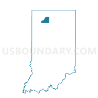
Outline

Summary
| Unique Area Identifier | 580649 |
| Name | NORTH BEND |
| County | Starke County |
| State | Indiana |
| Area (square miles) | 36.20 |
| Land Area (square miles) | 35.46 |
| Water Area (square miles) | 0.74 |
| % of Land Area | 97.97 |
| % of Water Area | 2.03 |
| Latitude of the Internal Point | 41.21351530 |
| Longtitude of the Internal Point | -86.52711520 |
Maps


Graphs
Select a template below for downloading or customizing gragh for NORTH BEND, Starke County, Indiana


Neighbors
Neighoring Voting District (by Name) Neighboring Voting District on the Map
- AUUBBEEBAUBEE, Fulton County, IN
- CALIFORNIA 01, Starke County, IN
- CENTER 05, Starke County, IN
- FRANKLIN, Pulaski County, IN
- TIPPECANOE, Pulaski County, IN
- UNION 2, Marshall County, IN
- WASHINGTON 02, Starke County, IN
Top 10 Neighboring County Subdivision (by Population) Neighboring County Subdivision on the Map
- Center township, Starke County, IN (6,229)
- Union township, Marshall County, IN (3,088)
- Washington township, Starke County, IN (3,003)
- California township, Starke County, IN (2,011)
- Aubbeenaubbee township, Fulton County, IN (1,448)
- North Bend township, Starke County, IN (1,394)
- Tippecanoe township, Pulaski County, IN (1,104)
- Franklin township, Pulaski County, IN (715)
Top 10 Neighboring Place (by Population) Neighboring Place on the Map
Top 10 Neighboring Unified School District (by Population) Neighboring Unified School District on the Map
- Knox Community School Corporation, IN (11,089)
- Eastern Pulaski Community School Corporation, IN (7,484)
- Culver Community Schools Corporation, IN (7,034)
Top 10 Neighboring State Legislative District Lower Chamber (by Population) Neighboring State Legislative District Lower Chamber on the Map
- State House District 16, IN (63,265)
- State House District 17, IN (61,387)
- State House District 20, IN (59,794)
Top 10 Neighboring State Legislative District Upper Chamber (by Population) Neighboring State Legislative District Upper Chamber on the Map
Top 10 Neighboring 111th Congressional District (by Population) Neighboring 111th Congressional District on the Map
Top 10 Neighboring Census Tract (by Population) Neighboring Census Tract on the Map
- Census Tract 9532, Fulton County, IN (3,797)
- Census Tract 9538, Starke County, IN (3,565)
- Census Tract 203.02, Marshall County, IN (3,088)
- Census Tract 9589, Pulaski County, IN (2,792)
- Census Tract 9539, Starke County, IN (2,035)