


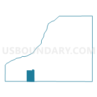
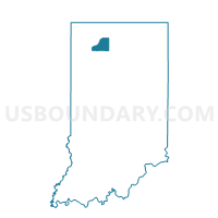
WAYNE 01, Starke County, Indiana
About
Outline

Summary
| Unique Area Identifier | 580637 |
| Name | WAYNE 01 |
| County | Starke County |
| State | Indiana |
| Area (square miles) | 6.18 |
| Land Area (square miles) | 6.18 |
| Water Area (square miles) | 0.00 |
| % of Land Area | 100.00 |
| % of Water Area | 0.00 |
| Latitude of the Internal Point | 41.19376820 |
| Longtitude of the Internal Point | -86.79473620 |
Maps

Graphs
Select a template below for downloading or customizing gragh for WAYNE 01, Starke County, Indiana


Neighbors
Neighoring Voting District (by Name) Neighboring Voting District on the Map
- CASS, Pulaski County, IN
- RAILROAD, Starke County, IN
- RICH GROVE, Pulaski County, IN
- WAYNE 02, Starke County, IN
- WAYNE 04, Starke County, IN
Top 10 Neighboring County Subdivision (by Population) Neighboring County Subdivision on the Map
- Wayne township, Starke County, IN (4,541)
- Railroad township, Starke County, IN (1,226)
- Rich Grove township, Pulaski County, IN (921)
- Cass township, Pulaski County, IN (878)