


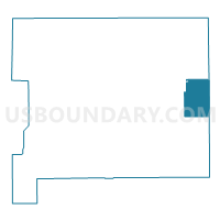
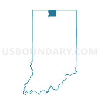
PENN TWP 03, St. Joseph County, Indiana
About
Outline

Summary
| Unique Area Identifier | 580458 |
| Name | PENN TWP 03 |
| County | St. Joseph County |
| State | Indiana |
| Area (square miles) | 13.08 |
| Land Area (square miles) | 13.08 |
| Water Area (square miles) | 0.00 |
| % of Land Area | 100.00 |
| % of Water Area | 0.00 |
| Latitude of the Internal Point | 41.61846890 |
| Longtitude of the Internal Point | -86.08879930 |
Maps

Graphs
Select a template below for downloading or customizing gragh for PENN TWP 03, St. Joseph County, Indiana


Neighbors
Neighoring Voting District (by Name) Neighboring Voting District on the Map
- BAUGO 73, Elkhart County, IN
- MADISON TWP 01, St. Joseph County, IN
- MISHAWAKA 090304, St. Joseph County, IN
- MISHAWAKA 090306, St. Joseph County, IN
- OLIVE 91, Elkhart County, IN
- PENN TWP 05, St. Joseph County, IN
- PENN TWP 08, St. Joseph County, IN
Top 10 Neighboring County Subdivision (by Population) Neighboring County Subdivision on the Map
- Penn township, St. Joseph County, IN (66,198)
- Baugo township, Elkhart County, IN (9,431)
- Olive township, Elkhart County, IN (3,068)
- Madison township, St. Joseph County, IN (1,913)
Top 10 Neighboring Place (by Population) Neighboring Place on the Map
Top 10 Neighboring Unified School District (by Population) Neighboring Unified School District on the Map
- Penn-Harris-Madison School Corporation, IN (61,138)
- Mishawaka School City, IN (30,427)
- Wa-Nee Community Schools, IN (20,657)
- Baugo Community Schools, IN (9,431)
Top 10 Neighboring State Legislative District Lower Chamber (by Population) Neighboring State Legislative District Lower Chamber on the Map
- State House District 21, IN (64,156)
- State House District 5, IN (62,790)
- State House District 23, IN (60,512)
Top 10 Neighboring State Legislative District Upper Chamber (by Population) Neighboring State Legislative District Upper Chamber on the Map
Top 10 Neighboring 111th Congressional District (by Population) Neighboring 111th Congressional District on the Map
Top 10 Neighboring Census Tract (by Population) Neighboring Census Tract on the Map
- Census Tract 14, Elkhart County, IN (9,431)
- Census Tract 117.02, St. Joseph County, IN (7,854)
- Census Tract 13, Elkhart County, IN (7,601)
- Census Tract 116.02, St. Joseph County, IN (7,340)
- Census Tract 117.01, St. Joseph County, IN (4,049)
- Census Tract 105, St. Joseph County, IN (2,927)
- Census Tract 124, St. Joseph County, IN (1,909)