


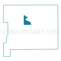
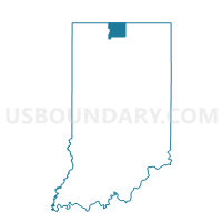
PORTAGE TWP 06, St. Joseph County, Indiana
About
Outline

Summary
| Unique Area Identifier | 580455 |
| Name | PORTAGE TWP 06 |
| County | St. Joseph County |
| State | Indiana |
| Area (square miles) | 6.69 |
| Land Area (square miles) | 6.69 |
| Water Area (square miles) | 0.00 |
| % of Land Area | 100.00 |
| % of Water Area | 0.00 |
| Latitude of the Internal Point | 41.65627980 |
| Longtitude of the Internal Point | -86.32972720 |
Maps

Graphs
Select a template below for downloading or customizing gragh for PORTAGE TWP 06, St. Joseph County, Indiana


Neighbors
Neighoring Voting District (by Name) Neighboring Voting District on the Map
- CENTRE TWP 08, St. Joseph County, IN
- GERMAN TWP 03, St. Joseph County, IN
- GREENE TWP 01, St. Joseph County, IN
- GREENE TWP 02, St. Joseph County, IN
- PORTAGE TWP 02, St. Joseph County, IN
- PORTAGE TWP 03, St. Joseph County, IN
- SOUTH BEND 130219, St. Joseph County, IN
- SOUTH BEND 130613, St. Joseph County, IN
- SOUTH BEND 130620, St. Joseph County, IN
- SOUTH BEND 130621, St. Joseph County, IN
- SOUTH BEND 130625, St. Joseph County, IN
- SOUTH BEND 130626, St. Joseph County, IN
- WARREN TWP 01, St. Joseph County, IN
- WARREN TWP 02, St. Joseph County, IN
- WARREN TWP 03, St. Joseph County, IN
- WARREN TWP 04, St. Joseph County, IN
Top 10 Neighboring County Subdivision (by Population) Neighboring County Subdivision on the Map
- Portage township, St. Joseph County, IN (93,063)
- Centre township, St. Joseph County, IN (14,350)
- German township, St. Joseph County, IN (9,319)
- Warren township, St. Joseph County, IN (7,605)
- Greene township, St. Joseph County, IN (3,216)
Top 10 Neighboring Place (by Population) Neighboring Place on the Map
Top 10 Neighboring Unified School District (by Population) Neighboring Unified School District on the Map
Top 10 Neighboring State Legislative District Lower Chamber (by Population) Neighboring State Legislative District Lower Chamber on the Map
Top 10 Neighboring State Legislative District Upper Chamber (by Population) Neighboring State Legislative District Upper Chamber on the Map
- State Senate District 9, IN (135,161)
- State Senate District 8, IN (127,082)
- State Senate District 10, IN (110,298)
Top 10 Neighboring 111th Congressional District (by Population) Neighboring 111th Congressional District on the Map
Top 10 Neighboring Census Tract (by Population) Neighboring Census Tract on the Map
- Census Tract 109, St. Joseph County, IN (7,754)
- Census Tract 111, St. Joseph County, IN (4,611)
- Census Tract 120, St. Joseph County, IN (3,976)
- Census Tract 34, St. Joseph County, IN (3,709)
- Census Tract 26, St. Joseph County, IN (3,213)
- Census Tract 28, St. Joseph County, IN (2,390)
- Census Tract 25, St. Joseph County, IN (2,129)