


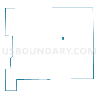
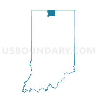
SOUTH BEND 130521, St. Joseph County, Indiana
About
Outline

Summary
| Unique Area Identifier | 580378 |
| Name | SOUTH BEND 130521 |
| County | St. Joseph County |
| State | Indiana |
| Area (square miles) | 0.23 |
| Land Area (square miles) | 0.23 |
| Water Area (square miles) | 0.00 |
| % of Land Area | 100.00 |
| % of Water Area | 0.00 |
| Latitude of the Internal Point | 41.64043760 |
| Longtitude of the Internal Point | -86.21993410 |
Maps

Graphs
Select a template below for downloading or customizing gragh for SOUTH BEND 130521, St. Joseph County, Indiana


Neighbors
Neighoring Voting District (by Name) Neighboring Voting District on the Map
- SOUTH BEND 130509, St. Joseph County, IN
- SOUTH BEND 130516, St. Joseph County, IN
- SOUTH BEND 130517, St. Joseph County, IN
- SOUTH BEND 130523, St. Joseph County, IN
- SOUTH BEND 130527, St. Joseph County, IN
Top 10 Neighboring County Subdivision (by Population) Neighboring County Subdivision on the Map
- Portage township, St. Joseph County, IN (93,063)
- Penn township, St. Joseph County, IN (66,198)
- Centre township, St. Joseph County, IN (14,350)
Top 10 Neighboring Place (by Population) Neighboring Place on the Map
Top 10 Neighboring Unified School District (by Population) Neighboring Unified School District on the Map
- South Bend Community School Corporation, IN (160,103)
- Penn-Harris-Madison School Corporation, IN (61,138)