


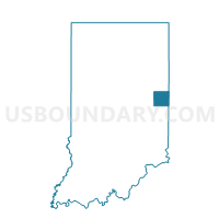
UNION, Randolph County, Indiana
About
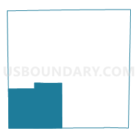
Outline

Summary
| Unique Area Identifier | 580260 |
| Name | UNION |
| County | Randolph County |
| State | Indiana |
| Area (square miles) | 71.65 |
| Land Area (square miles) | 71.52 |
| Water Area (square miles) | 0.13 |
| % of Land Area | 99.81 |
| % of Water Area | 0.19 |
| Latitude of the Internal Point | 40.05417730 |
| Longtitude of the Internal Point | -85.12162100 |
Maps

Graphs
Select a template below for downloading or customizing gragh for UNION, Randolph County, Indiana


Neighbors
Neighoring Voting District (by Name) Neighboring Voting District on the Map
- BLUE RIVER, Henry County, IN
- DALTON 01, Wayne County, IN
- GREENE 01, Wayne County, IN
- PERRY 01, Wayne County, IN
- PRECINCT 62, Delaware County, IN
- STONEY CREEK, Henry County, IN
- STONEY CREEK, Randolph County, IN
- WASHINGTON, Randolph County, IN
- WHITE RIVER 2, Randolph County, IN
Top 10 Neighboring County Subdivision (by Population) Neighboring County Subdivision on the Map
- White River township, Randolph County, IN (7,513)
- Washington township, Randolph County, IN (2,172)
- Union township, Randolph County, IN (2,142)
- Perry township, Delaware County, IN (1,511)
- Blue River township, Henry County, IN (1,224)
- Green township, Wayne County, IN (1,222)
- Stoney Creek township, Randolph County, IN (990)
- Perry township, Wayne County, IN (835)
- Stoney Creek township, Henry County, IN (817)
- Dalton township, Wayne County, IN (566)
Top 10 Neighboring Place (by Population) Neighboring Place on the Map
Top 10 Neighboring Unified School District (by Population) Neighboring Unified School District on the Map
- Randolph Central School Corporation, IN (9,887)
- Nettle Creek School Corporation, IN (7,123)
- Blue River Valley Schools, IN (6,739)
- Liberty-Perry Community School Corporation, IN (6,196)
- Northeastern Wayne Schools, IN (5,841)
- Monroe Central School Corporation, IN (5,658)
- Randolph Southern School Corporation, IN (3,254)
- Union School Corporation, IN (2,959)
Top 10 Neighboring State Legislative District Lower Chamber (by Population) Neighboring State Legislative District Lower Chamber on the Map
Top 10 Neighboring State Legislative District Upper Chamber (by Population) Neighboring State Legislative District Upper Chamber on the Map
- State Senate District 28, IN (171,077)
- State Senate District 26, IN (119,532)
- State Senate District 27, IN (116,341)
Top 10 Neighboring 111th Congressional District (by Population) Neighboring 111th Congressional District on the Map
Top 10 Neighboring Census Tract (by Population) Neighboring Census Tract on the Map
- Census Tract 22, Delaware County, IN (6,196)
- Census Tract 9519, Randolph County, IN (4,529)
- Census Tract 9756, Henry County, IN (4,215)
- Census Tract 103, Wayne County, IN (3,525)
- Census Tract 9521, Randolph County, IN (3,023)
Top 10 Neighboring 5-Digit ZIP Code Tabulation Area (by Population) Neighboring 5-Digit ZIP Code Tabulation Area on the Map
- 47394, IN (8,470)
- 47340, IN (2,914)
- 47355, IN (2,885)
- 47368, IN (2,845)
- 47393, IN (1,704)
- 47360, IN (1,546)
- 47354, IN (1,129)
- 47358, IN (996)
- 47339, IN (669)