


SOUTHEAST, Orange County, Indiana
About
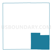
Outline

Summary
| Unique Area Identifier | 579960 |
| Name | SOUTHEAST |
| County | Orange County |
| State | Indiana |
| Area (square miles) | 53.33 |
| Land Area (square miles) | 53.21 |
| Water Area (square miles) | 0.12 |
| % of Land Area | 99.77 |
| % of Water Area | 0.23 |
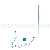
| Latitude of the Internal Point | 38.44446740 |
| Longtitude of the Internal Point | -86.38259950 |
Maps

Graphs
Select a template below for downloading or customizing gragh for SOUTHEAST, Orange County, Indiana


Neighbors
Neighoring Voting District (by Name) Neighboring Voting District on the Map
- GREENFIELD, Orange County, IN
- LIBERTY 01, Crawford County, IN
- MADISON, Washington County, IN
- PAOLI SOUTHEAST, Orange County, IN
- PAOLI SOUTHWEST, Orange County, IN
- STAMPERS CREEK, Orange County, IN
- STERLING 01, Crawford County, IN
- STERLING 02, Crawford County, IN
- WEST POSEY, Washington County, IN
- WHISKEY RUN 01, Crawford County, IN
Top 10 Neighboring County Subdivision (by Population) Neighboring County Subdivision on the Map
- Paoli township, Orange County, IN (6,031)
- Liberty township, Crawford County, IN (1,990)
- Whiskey Run township, Crawford County, IN (1,911)
- Posey township, Washington County, IN (1,888)
- Sterling township, Crawford County, IN (1,635)
- Southeast township, Orange County, IN (1,603)
- Stampers Creek township, Orange County, IN (954)
- Greenfield township, Orange County, IN (730)
- Madison township, Washington County, IN (705)
Top 10 Neighboring Unified School District (by Population) Neighboring Unified School District on the Map
- Crawford County Community School Corporation, IN (11,086)
- Paoli Community School Corporation, IN (9,318)
- West Washington School Corporation, IN (5,723)
Top 10 Neighboring State Legislative District Lower Chamber (by Population) Neighboring State Legislative District Lower Chamber on the Map
Top 10 Neighboring State Legislative District Upper Chamber (by Population) Neighboring State Legislative District Upper Chamber on the Map
- State Senate District 47, IN (128,339)
- State Senate District 44, IN (123,667)
- State Senate District 48, IN (121,761)
Top 10 Neighboring 111th Congressional District (by Population) Neighboring 111th Congressional District on the Map
Top 10 Neighboring Census Tract (by Population) Neighboring Census Tract on the Map
- Census Tract 9674, Washington County, IN (4,700)
- Census Tract 9520, Crawford County, IN (4,031)
- Census Tract 9519, Crawford County, IN (3,805)
- Census Tract 9518, Orange County, IN (3,525)
- Census Tract 9516, Orange County, IN (3,472)
Top 10 Neighboring 5-Digit ZIP Code Tabulation Area (by Population) Neighboring 5-Digit ZIP Code Tabulation Area on the Map
- 47454, IN (7,688)
- 47452, IN (5,359)
- 47118, IN (3,502)
- 47140, IN (2,669)
- 47145, IN (1,998)
- 47125, IN (1,658)