


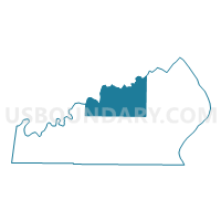
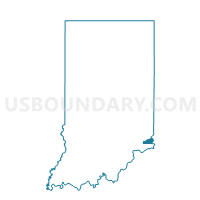
UNION 9, Ohio County, Indiana
About
Outline

Summary
| Unique Area Identifier | 579950 |
| Name | UNION 9 |
| County | Ohio County |
| State | Indiana |
| Area (square miles) | 11.61 |
| Land Area (square miles) | 11.52 |
| Water Area (square miles) | 0.09 |
| % of Land Area | 99.24 |
| % of Water Area | 0.76 |
| Latitude of the Internal Point | 38.97752080 |
| Longtitude of the Internal Point | -84.96941690 |
Maps

Graphs
Select a template below for downloading or customizing gragh for UNION 9, Ohio County, Indiana


Neighbors
Neighoring Voting District (by Name) Neighboring Voting District on the Map
- CASS 7, Ohio County, IN
- CENTER 5, Dearborn County, IN
- CLAY 2, Dearborn County, IN
- PIKE 8, Ohio County, IN
- RANDOLPH 5, Ohio County, IN
- RANDOLPH 6, Ohio County, IN
- WASHINGTON 1, Dearborn County, IN
Top 10 Neighboring County Subdivision (by Population) Neighboring County Subdivision on the Map
- Center township, Dearborn County, IN (5,318)
- Randolph township, Ohio County, IN (4,383)
- Clay township, Dearborn County, IN (2,966)
- Washington township, Dearborn County, IN (1,431)
- Cass township, Ohio County, IN (714)
- Pike township, Ohio County, IN (527)
- Union township, Ohio County, IN (504)
Top 10 Neighboring Unified School District (by Population) Neighboring Unified School District on the Map
- South Dearborn Community School Corporation, IN (17,247)
- Rising Sun-Ohio County Community Schools, IN (6,128)