


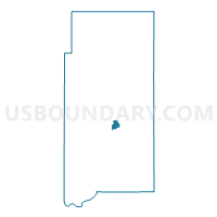
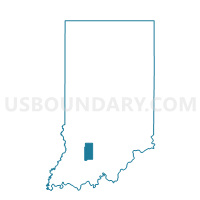
EAST MEMPHIS, Martin County, Indiana
About
Outline

Summary
| Unique Area Identifier | 579712 |
| Name | EAST MEMPHIS |
| County | Martin County |
| State | Indiana |
| Area (square miles) | 0.79 |
| Land Area (square miles) | 0.76 |
| Water Area (square miles) | 0.03 |
| % of Land Area | 96.20 |
| % of Water Area | 3.80 |
| Latitude of the Internal Point | 38.66873770 |
| Longtitude of the Internal Point | -86.78399610 |
Maps

Graphs
Select a template below for downloading or customizing gragh for EAST MEMPHIS, Martin County, Indiana


Neighbors
Neighoring Voting District (by Name) Neighboring Voting District on the Map
- NORTH CENTER, Martin County, IN
- NORTH HALBERT, Martin County, IN
- SOUTH CENTER, Martin County, IN
- SOUTH HALBERT, Martin County, IN
- WEST MEMPHIS, Martin County, IN