


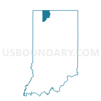
SPRINGFIELD 2, LaPorte County, Indiana
About
Outline

Summary
| Unique Area Identifier | 578930 |
| Name | SPRINGFIELD 2 |
| County | LaPorte County |
| State | Indiana |
| Area (square miles) | 16.70 |
| Land Area (square miles) | 16.58 |
| Water Area (square miles) | 0.12 |
| % of Land Area | 99.30 |
| % of Water Area | 0.70 |
| Latitude of the Internal Point | 41.72592470 |
| Longtitude of the Internal Point | -86.73748470 |
Maps


Graphs
Select a template below for downloading or customizing gragh for SPRINGFIELD 2, LaPorte County, Indiana


Neighbors
Neighoring Voting District (by Name) Neighboring Voting District on the Map
- Voting District 0215723000001, Berrien County, MI
- CENTER 2, LaPorte County, IN
- GALENA, LaPorte County, IN
- KANKAKEE 1, LaPorte County, IN
- SPRINGFIELD 1, LaPorte County, IN
- SPRINGFIELD 3, LaPorte County, IN
Top 10 Neighboring County Subdivision (by Population) Neighboring County Subdivision on the Map
- Center township, LaPorte County, IN (25,075)
- Kankakee township, LaPorte County, IN (4,830)
- Springfield township, LaPorte County, IN (4,045)
- New Buffalo township, Berrien County, MI (2,386)
- Galena township, LaPorte County, IN (1,899)
Top 10 Neighboring Unified School District (by Population) Neighboring Unified School District on the Map
- Michigan City Area Schools, IN (48,411)
- La Porte Community School Corporation, IN (38,631)
- New Prairie United School Corporation, IN (15,332)
- New Buffalo Area School District, MI (4,503)
Top 10 Neighboring State Legislative District Lower Chamber (by Population) Neighboring State Legislative District Lower Chamber on the Map
- State House District 78, MI (86,900)
- State House District 9, IN (63,447)
- State House District 20, IN (59,794)
Top 10 Neighboring State Legislative District Upper Chamber (by Population) Neighboring State Legislative District Upper Chamber on the Map
Top 10 Neighboring 111th Congressional District (by Population) Neighboring 111th Congressional District on the Map
Top 10 Neighboring Census Tract (by Population) Neighboring Census Tract on the Map
- Census Tract 416, LaPorte County, IN (6,330)
- Census Tract 113, Berrien County, MI (4,269)
- Census Tract 417, LaPorte County, IN (3,395)