


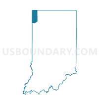
HAMMOND 01-16, Lake County, Indiana
About
Outline

Summary
| Unique Area Identifier | 578428 |
| Name | HAMMOND 01-16 |
| County | Lake County |
| State | Indiana |
| Area (square miles) | 0.13 |
| Land Area (square miles) | 0.13 |
| Water Area (square miles) | 0.00 |
| % of Land Area | 100.00 |
| % of Water Area | 0.00 |
| Latitude of the Internal Point | 41.63310130 |
| Longtitude of the Internal Point | -87.51208510 |
Maps


Graphs
Select a template below for downloading or customizing gragh for HAMMOND 01-16, Lake County, Indiana


Neighbors
Neighoring Voting District (by Name) Neighboring Voting District on the Map
- HAMMOND 01-14, Lake County, IN
- HAMMOND 01-15, Lake County, IN
- HAMMOND 02-03, Lake County, IN
- HAMMOND 02-05, Lake County, IN