


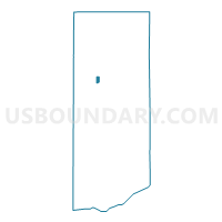
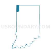
GRIFFITH PRECINCT 15, Lake County, Indiana
About
Outline

Summary
| Unique Area Identifier | 578363 |
| Name | GRIFFITH PRECINCT 15 |
| County | Lake County |
| State | Indiana |
| Area (square miles) | 0.58 |
| Land Area (square miles) | 0.58 |
| Water Area (square miles) | 0.00 |
| % of Land Area | 100.00 |
| % of Water Area | 0.00 |
| Latitude of the Internal Point | 41.55783300 |
| Longtitude of the Internal Point | -87.42790770 |
Maps

Graphs
Select a template below for downloading or customizing gragh for GRIFFITH PRECINCT 15, Lake County, Indiana


Neighbors
Neighoring Voting District (by Name) Neighboring Voting District on the Map
- GARY 03-03, Lake County, IN
- GRIFFITH PRECINCT 01, Lake County, IN
- GRIFFITH PRECINCT 02, Lake County, IN
- GRIFFITH PRECINCT 12, Lake County, IN
- HIGHLAND PRECINCT 12, Lake County, IN
- HIGHLAND PRECINCT 16, Lake County, IN
- HIGHLAND PRECINCT 24, Lake County, IN
Top 10 Neighboring County Subdivision (by Population) Neighboring County Subdivision on the Map
Top 10 Neighboring Place (by Population) Neighboring Place on the Map
Top 10 Neighboring Unified School District (by Population) Neighboring Unified School District on the Map
- Highland School Town, IN (23,727)
- Griffith Public Schools, IN (16,795)
- Lake Ridge Schools, IN (12,182)
Top 10 Neighboring State Legislative District Lower Chamber (by Population) Neighboring State Legislative District Lower Chamber on the Map
Top 10 Neighboring State Legislative District Upper Chamber (by Population) Neighboring State Legislative District Upper Chamber on the Map
Top 10 Neighboring 111th Congressional District (by Population) Neighboring 111th Congressional District on the Map
Top 10 Neighboring Census Tract (by Population) Neighboring Census Tract on the Map
- Census Tract 410.01, Lake County, IN (5,525)
- Census Tract 407, Lake County, IN (5,031)
- Census Tract 408.01, Lake County, IN (3,888)
- Census Tract 411, Lake County, IN (2,377)