


UNION 02, Johnson County, Indiana
About
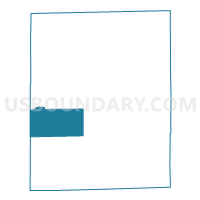
Outline

Summary
| Unique Area Identifier | 578132 |
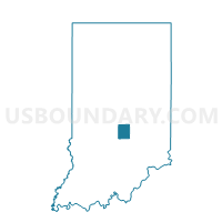
| Name | UNION 02 |
| County | Johnson County |
| State | Indiana |
| Area (square miles) | 18.81 |
| Land Area (square miles) | 18.80 |
| Water Area (square miles) | 0.01 |
| % of Land Area | 99.94 |
| % of Water Area | 0.06 |
| Latitude of the Internal Point | 39.45243890 |
| Longtitude of the Internal Point | -86.19764490 |
Maps

Graphs
Select a template below for downloading or customizing gragh for UNION 02, Johnson County, Indiana


Neighbors
Neighoring Voting District (by Name) Neighboring Voting District on the Map
- FRANKLIN 01, Johnson County, IN
- GREEN 02, Morgan County, IN
- HENSLEY 01, Johnson County, IN
- NINEVEH 03, Johnson County, IN
- UNION 01, Johnson County, IN
Top 10 Neighboring County Subdivision (by Population) Neighboring County Subdivision on the Map
- Franklin township, Johnson County, IN (20,685)
- Nineveh township, Johnson County, IN (3,987)
- Green township, Morgan County, IN (3,520)
- Hensley township, Johnson County, IN (3,329)
- Union township, Johnson County, IN (2,689)
Top 10 Neighboring Unified School District (by Population) Neighboring Unified School District on the Map
- Martinsville Schools Metropolitan School District, IN (30,507)
- Franklin Community School Corporation, IN (29,885)
- Nineveh-Hensley-Jackson United School Corporation, IN (10,425)
Top 10 Neighboring State Legislative District Lower Chamber (by Population) Neighboring State Legislative District Lower Chamber on the Map
Top 10 Neighboring State Legislative District Upper Chamber (by Population) Neighboring State Legislative District Upper Chamber on the Map
Top 10 Neighboring 111th Congressional District (by Population) Neighboring 111th Congressional District on the Map
Top 10 Neighboring Census Tract (by Population) Neighboring Census Tract on the Map
- Census Tract 5106, Morgan County, IN (8,481)
- Census Tract 6114, Johnson County, IN (7,316)
- Census Tract 6108.01, Johnson County, IN (6,988)