


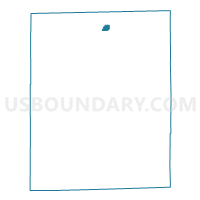
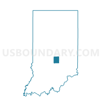
PLEASANT 17, Johnson County, Indiana
About
Outline

Summary
| Unique Area Identifier | 578109 |
| Name | PLEASANT 17 |
| County | Johnson County |
| State | Indiana |
| Area (square miles) | 0.36 |
| Land Area (square miles) | 0.36 |
| Water Area (square miles) | 0.00 |
| % of Land Area | 100.00 |
| % of Water Area | 0.00 |
| Latitude of the Internal Point | 39.60972890 |
| Longtitude of the Internal Point | -86.08910930 |
Maps

Graphs
Select a template below for downloading or customizing gragh for PLEASANT 17, Johnson County, Indiana


Neighbors
Neighoring Voting District (by Name) Neighboring Voting District on the Map
- PLEASANT 09, Johnson County, IN
- PLEASANT 20, Johnson County, IN
- PLEASANT 29, Johnson County, IN
- PLEASANT 32, Johnson County, IN
- PLEASANT 40, Johnson County, IN
Top 10 Neighboring County Subdivision (by Population) Neighboring County Subdivision on the Map
Top 10 Neighboring Place (by Population) Neighboring Place on the Map
Top 10 Neighboring Unified School District (by Population) Neighboring Unified School District on the Map
- Clark-Pleasant Community School Corporation, IN (32,318)
- Greenwood Community School Corporation, IN (24,542)