


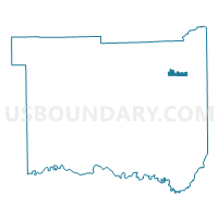
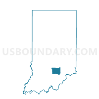
REDDING SEYMOUR CITY, Jackson County, Indiana
About
Outline

Summary
| Unique Area Identifier | 577927 |
| Name | REDDING SEYMOUR CITY |
| County | Jackson County |
| State | Indiana |
| Area (square miles) | 1.29 |
| Land Area (square miles) | 1.29 |
| Water Area (square miles) | 0.00 |
| % of Land Area | 99.76 |
| % of Water Area | 0.24 |
| Latitude of the Internal Point | 38.97255530 |
| Longtitude of the Internal Point | -85.88351880 |
Maps

Graphs
Select a template below for downloading or customizing gragh for REDDING SEYMOUR CITY, Jackson County, Indiana


Neighbors
Neighoring Voting District (by Name) Neighboring Voting District on the Map
- JACKSON 1 EAST, Jackson County, IN
- JACKSON 1 WEST, Jackson County, IN
- JACKSON 5 NORTH, Jackson County, IN
- JACKSON 6, Jackson County, IN
- JACKSON 7, Jackson County, IN
- REDDING WEST, Jackson County, IN