


LIBERTY 02, Hendricks County, Indiana
About
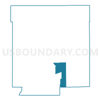
Outline

Summary
| Unique Area Identifier | 577711 |
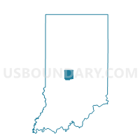
| Name | LIBERTY 02 |
| County | Hendricks County |
| State | Indiana |
| Area (square miles) | 10.77 |
| Land Area (square miles) | 10.68 |
| Water Area (square miles) | 0.09 |
| % of Land Area | 99.15 |
| % of Water Area | 0.85 |
| Latitude of the Internal Point | 39.69694720 |
| Longtitude of the Internal Point | -86.45042400 |
Maps

Graphs
Select a template below for downloading or customizing gragh for LIBERTY 02, Hendricks County, Indiana


Neighbors
Neighoring Voting District (by Name) Neighboring Voting District on the Map
- CENTER 09, Hendricks County, IN
- CENTER 4, Hendricks County, IN
- GUILFORD 09, Hendricks County, IN
- GUILFORD 18, Hendricks County, IN
- GUILFORD 20, Hendricks County, IN
- LIBERTY 01, Hendricks County, IN
- LIBERTY 03, Hendricks County, IN
- LIBERTY 05, Hendricks County, IN
- MONROE 01, Morgan County, IN
- WASHINGTON 08, Hendricks County, IN
Top 10 Neighboring County Subdivision (by Population) Neighboring County Subdivision on the Map
- Washington township, Hendricks County, IN (44,764)
- Guilford township, Hendricks County, IN (27,844)
- Center township, Hendricks County, IN (12,167)
- Liberty township, Hendricks County, IN (5,772)
- Monroe township, Morgan County, IN (4,904)
Top 10 Neighboring Place (by Population) Neighboring Place on the Map
Top 10 Neighboring Unified School District (by Population) Neighboring Unified School District on the Map
- Avon Community School Corporation, IN (44,764)
- Plainfield Community School Corporation, IN (27,844)
- Danville Community School Corporation, IN (13,569)
- Mill Creek Community School Corporation, IN (9,325)
- Monroe-Gregg School District, IN (7,834)
Top 10 Neighboring State Legislative District Lower Chamber (by Population) Neighboring State Legislative District Lower Chamber on the Map
- State House District 40, IN (94,412)
- State House District 91, IN (75,356)
- State House District 28, IN (69,656)
- State House District 47, IN (62,157)
Top 10 Neighboring State Legislative District Upper Chamber (by Population) Neighboring State Legislative District Upper Chamber on the Map
Top 10 Neighboring 111th Congressional District (by Population) Neighboring 111th Congressional District on the Map
Top 10 Neighboring Census Tract (by Population) Neighboring Census Tract on the Map
- Census Tract 2107, Hendricks County, IN (10,399)
- Census Tract 2106.05, Hendricks County, IN (9,884)
- Census Tract 2105.02, Hendricks County, IN (5,908)
- Census Tract 2110, Hendricks County, IN (5,772)
- Census Tract 5104.02, Morgan County, IN (5,089)