


CLEVELAND 108, Elkhart County, Indiana
About
Outline

Summary
| Unique Area Identifier | 576999 |
| Name | CLEVELAND 108 |
| County | Elkhart County |
| State | Indiana |
| Area (square miles) | 5.68 |
| Land Area (square miles) | 5.57 |
| Water Area (square miles) | 0.11 |
| % of Land Area | 98.11 |
| % of Water Area | 1.89 |
| Latitude of the Internal Point | 41.74822980 |
| Longtitude of the Internal Point | -86.04538860 |
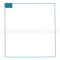
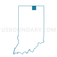
Maps

Graphs
Select a template below for downloading or customizing gragh for CLEVELAND 108, Elkhart County, Indiana


Neighbors
Neighoring Voting District (by Name) Neighboring Voting District on the Map
- Voting District 0276090000001, Cass County, MI
- Voting District 0276090000002, Cass County, MI
- CLEVELAND 79, Elkhart County, IN
- CLEVELAND 80, Elkhart County, IN
- HARRIS TWP 09, St. Joseph County, IN
- HARRIS TWP 11, St. Joseph County, IN
- OSOLO 104, Elkhart County, IN
- OSOLO 64, Elkhart County, IN
Top 10 Neighboring County Subdivision (by Population) Neighboring County Subdivision on the Map
- Osolo township, Elkhart County, IN (28,032)
- Harris township, St. Joseph County, IN (23,454)
- Cleveland township, Elkhart County, IN (11,158)
- Ontwa township, Cass County, MI (6,549)
Top 10 Neighboring Place (by Population) Neighboring Place on the Map
Top 10 Neighboring Unified School District (by Population) Neighboring Unified School District on the Map
- Elkhart Community Schools, IN (75,567)
- Penn-Harris-Madison School Corporation, IN (61,138)
- Edwardsburg Public Schools, MI (12,713)
Top 10 Neighboring State Legislative District Lower Chamber (by Population) Neighboring State Legislative District Lower Chamber on the Map
Top 10 Neighboring State Legislative District Upper Chamber (by Population) Neighboring State Legislative District Upper Chamber on the Map
Top 10 Neighboring 111th Congressional District (by Population) Neighboring 111th Congressional District on the Map
- Congressional District 3, IN (723,633)
- Congressional District 2, IN (679,254)
- Congressional District 6, MI (671,883)
Top 10 Neighboring Census Tract (by Population) Neighboring Census Tract on the Map
- Census Tract 18, Cass County, MI (8,165)
- Census Tract 15.02, Elkhart County, IN (6,110)
- Census Tract 16.02, Elkhart County, IN (4,835)
- Census Tract 114.05, St. Joseph County, IN (3,528)
- Census Tract 12, Cass County, MI (3,204)